Agago geodata
Agago (Northern Region) is a seat of a second-order administrative division; located in Uganda in Africa/Kampala (GMT+3) time zone. In our database, there are 80 cities with bigger population. Compared to other cities in Uganda, 92.5% of cities are located further ↓South; 74% of cities are located further ←West and 91.8% of cities have higher elevation than Agago. Note1
Administrative division(s):
- Level 1: Northern Region
- Level 2: Agago District
- Level 3: Agago County
- Level 4: Agago Town Council


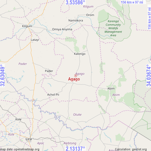
Agago GPS coordinates[2]
2° 50' 1.788" North, 33° 20' 0.996" East
| Map corner | latitude | longitude |
|---|---|---|
| Upper-left | 3.53586°, | 32.63049° |
| Center: | 2.83383°, | 33.33361° |
| Lower-right: | 2.13137°, | 34.03674° |
| Map W x H: | 156.2×156.2 km | = 97.1×97.1mi |
| max Lat: | 3.66088° ⇑7.5% North |
| Agago: | 2.83383° |
| min Lat: | ⇓92.5% South -1.28538° |
| min Long | Agago | max Long |
| 29.65° | 33.33361° | 34.95° |
| W 74%⇐ | ⇒26% E |
Elevation
Elevation of Agago is 1035 m = 3396 ft, and this is 224 m = 735 ft below average elevation for this country.
| Max E: |
4129 m = 13547 ft | 91.8% |
| Avg. | 1259 m = 4131 ft | |
| Agago | 1035 m = 3396 ft | |
Min E: |
622 m = 2041 ft | 8.2% |
See also: Uganda elevation on elevation.city.
Geographical zone
Agago is located in North Torrid zone (between Equator and Tropic of Cancer). Distance of Equator is 315.1 km =195.8 mi to South.| Distance of | km | miles | from Agago |
|---|---|---|---|
| North Pole | 9692 | 6022.3 | to North |
| Arctic Circle | 7086.1 | 4403.1 | to North |
| Tropic Cancer | 2290.8 | 1423.4 | to North |
| Equator | 315.1 | 195.8 | to South |


Nearby cities:
15 places around Agago: (largest is in red/bold)
• Abim
40.8 km =25.4 mi,  111°
111°
• Alebtong
66.1 km =41.1 mi,  187°
187°
• Amuria
98.8 km =61.4 mi,  159°
159°
• Dokolo
105.5 km =65.6 mi, 189°
• Gulu
115.1 km =71.5 mi,  266°
266°
• Kaabong
115.8 km =72 mi,  51°
51°
• Kitgum
70 km =43.5 mi,  314°
314°
• Kole
76.4 km =47.5 mi,  230°
230°
• Kotido
90.3 km =56.1 mi,  79°
79°
• Lamwo
97.3 km =60.5 mi,  322°
322°
• Lira
80.9 km =50.3 mi,  216°
216°
• Napak
120.7 km =75 mi,  122°
122°
• Otuke
41.5 km =25.8 mi,  153°
153°
• Pader
27.3 km =17 mi,  331°
331°
• Pader Palwo
22.4 km =13.9 mi,  260°
260°
Sources, notices
• [Note1] Compared only with cities in Uganda existing in our database
• [Src1] Map data: © OpenStreetMap contributors (CC-BY-SA)
• [Src2] Other city data from geonames.org with taken over terms of usage.
• [Src3] Geographical zone / Annual Mean Temperature by Robert A. Rohde @ Wikipedia
