Pader geodata
Pader (Northern Region) is a seat of a second-order administrative division; located in Uganda in Africa/Kampala (GMT+3) time zone. With population of 11,600 people, there are 56 cities with bigger population in this country. Compared to other cities in Uganda, 94.5% of cities are located further ↓South; 71.2% of cities are located further ←West and 86.3% of cities have higher elevation than Pader. Note1
Administrative division(s):
- Level 1: Northern Region
- Level 2: Agago District
- Level 3: Agago County
- Level 4: Wol


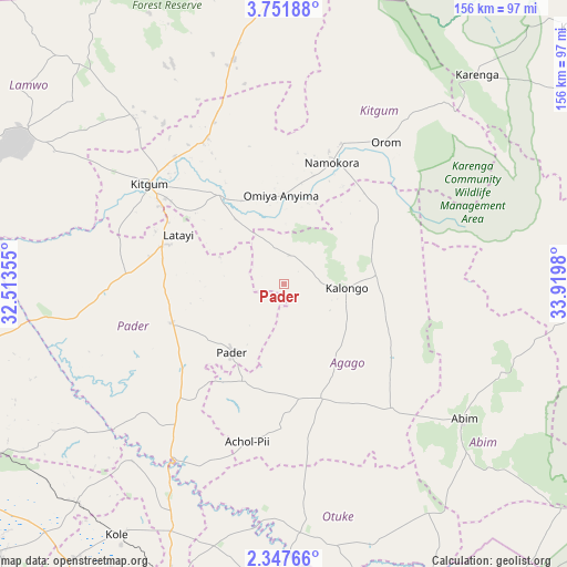
Pader GPS coordinates[2]
3° 3' 0" North, 33° 13' 0.012" East
| Map corner | latitude | longitude |
|---|---|---|
| Upper-left | 3.75188°, | 32.51355° |
| Center: | 3.05°, | 33.21667° |
| Lower-right: | 2.34766°, | 33.9198° |
| Map W x H: | 156.1×156.1 km | = 97×97mi |
| max Lat: | 3.66088° ⇑5.5% North |
| Pader: | 3.05° |
| min Lat: | ⇓94.5% South -1.28538° |
| min Long | Pader | max Long |
| 29.65° | 33.21667° | 34.95° |
| W 71.2%⇐ | ⇒28.8% E |
Elevation
Elevation of Pader is 1061 m = 3481 ft, and this is 198 m = 650 ft below average elevation for this country.
| Max E: |
4129 m = 13547 ft | 86.3% |
| Avg. | 1259 m = 4131 ft | |
| Pader | 1061 m = 3481 ft | |
Min E: |
622 m = 2041 ft | 13.7% |
See also: Uganda elevation on elevation.city.
Geographical zone
Pader is located in North Torrid zone (between Equator and Tropic of Cancer). Distance of Equator is 339.1 km =210.7 mi to South.| Distance of | km | miles | from Pader |
|---|---|---|---|
| North Pole | 9667.9 | 6007.4 | to North |
| Arctic Circle | 7062 | 4388.1 | to North |
| Tropic Cancer | 2266.8 | 1408.5 | to North |
| Equator | 339.1 | 210.7 | to South |


Nearby cities:
15 places around Pader: (largest is in red/bold)
• Abim
64.1 km =39.8 mi,  127°
127°
• Agago
27.3 km =17 mi,  151°
151°
• Alebtong
89.6 km =55.7 mi,  177°
177°
• Amuria
126 km =78.3 mi,  157°
157°
• Dokolo
128.1 km =79.6 mi, 181°
• Gulu
106.4 km =66.1 mi,  253°
253°
• Kaabong
114.2 km =71 mi,  65°
65°
• Kitgum
44.6 km =27.7 mi,  304°
304°
• Kole
85.8 km =53.3 mi,  212°
212°
• Kotido
102 km =63.4 mi,  94°
94°
• Lamwo
70.5 km =43.8 mi,  319°
319°
• Lira
95.7 km =59.5 mi,  201°
201°
• Otuke
68.8 km =42.8 mi, 152°
• Oyam
129.4 km =80.4 mi,  225°
225°
• Pader Palwo
29.2 km =18.1 mi, 198°
Sources, notices
• [Note1] Compared only with cities in Uganda existing in our database
• [Src1] Map data: © OpenStreetMap contributors (CC-BY-SA)
• [Src2] Other city data from geonames.org with taken over terms of usage.
• [Src3] Geographical zone / Annual Mean Temperature by Robert A. Rohde @ Wikipedia
