Kitgum geodata
Kitgum (Northern Region) is a seat of a second-order administrative division; located in Uganda in Africa/Kampala (GMT+3) time zone. With population of 56,891 people, there are 12 cities with bigger population in this country. Compared to other cities in Uganda, 95.9% of cities are located further ↓South; 61.6% of cities are located further ←West and 96.6% of cities have higher elevation than Kitgum. Note1
Administrative division(s):
- Level 1: Northern Region
- Level 2: Kitgum District
- Level 3: Chua County
- Level 4: Kitgum Town Council


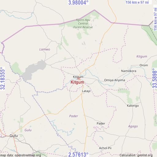
Kitgum GPS coordinates[2]
3° 16' 41.988" North, 32° 53' 12.012" East
| Map corner | latitude | longitude |
|---|---|---|
| Upper-left | 3.98004°, | 32.18355° |
| Center: | 3.27833°, | 32.88667° |
| Lower-right: | 2.57613°, | 33.5898° |
| Map W x H: | 156.1×156.1 km | = 97×97mi |
| max Lat: | 3.66088° ⇑4.1% North |
| Kitgum: | 3.27833° |
| min Lat: | ⇓95.9% South -1.28538° |
| min Long | Kitgum | max Long |
| 29.65° | 32.88667° | 34.95° |
| W 61.6%⇐ | ⇒38.4% E |
Elevation
Elevation of Kitgum is 950 m = 3117 ft, and this is 309 m = 1014 ft below average elevation for this country.
| Max E: |
4129 m = 13547 ft | 96.6% |
| Avg. | 1259 m = 4131 ft | |
| Kitgum | 950 m = 3117 ft | |
Min E: |
622 m = 2041 ft | 3.4% |
See also: Kitgum elevation on elevation.city.
Geographical zone
Kitgum is located in North Torrid zone (between Equator and Tropic of Cancer). Distance of Equator is 364.5 km =226.5 mi to South.| Distance of | km | miles | from Kitgum |
|---|---|---|---|
| North Pole | 9642.5 | 5991.6 | to North |
| Arctic Circle | 7036.7 | 4372.4 | to North |
| Tropic Cancer | 2241.4 | 1392.7 | to North |
| Equator | 364.5 | 226.5 | to South |


Nearby cities:
15 places around Kitgum: (largest is in red/bold)
• Abim
108.6 km =67.5 mi,  126°
126°
• Adjumani
122.1 km =75.9 mi,  275°
275°
• Agago
70 km =43.5 mi, 134°
• Alebtong
122 km =75.8 mi,  160°
160°
• Amuru
117.2 km =72.8 mi,  243°
243°
• Gulu
86 km =53.4 mi,  229°
229°
• Kole
98.1 km =61 mi,  185°
185°
• Lamwo
29.5 km =18.3 mi,  341°
341°
• Lira
114.4 km =71.1 mi,  179°
179°
• Moyo
135.8 km =84.4 mi,  288°
288°
• Nwoya
121.7 km =75.6 mi, 233°
• Otuke
110.1 km =68.4 mi,  141°
141°
• Oyam
128.7 km =80 mi,  205°
205°
• Pader
44.6 km =27.7 mi,  124°
124°
• Pader Palwo
59.9 km =37.2 mi,  152°
152°
Sources, notices
• [Note1] Compared only with cities in Uganda existing in our database
• [Src1] Map data: © OpenStreetMap contributors (CC-BY-SA)
• [Src2] Other city data from geonames.org with taken over terms of usage.
• [Src3] Geographical zone / Annual Mean Temperature by Robert A. Rohde @ Wikipedia
