Lira geodata
Lira (Northern Region) is a seat of a second-order administrative division; located in Uganda in Africa/Kampala (GMT+3) time zone. With population of 119,323 people, there are 2 cities with bigger population in this country. Compared to other cities in Uganda, 83.6% of cities are located further ↓South; 63% of cities are located further ←West and 76% of cities have higher elevation than Lira. Note1
Administrative division(s):
- Level 1: Northern Region
- Level 2: Lira District
- Level 3: Lira Municipality
- Level 4: Central Division


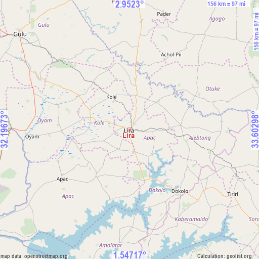
Lira GPS coordinates[2]
2° 14' 59.64" North, 32° 53' 59.46" East
| Map corner | latitude | longitude |
|---|---|---|
| Upper-left | 2.9523°, | 32.19673° |
| Center: | 2.2499°, | 32.89985° |
| Lower-right: | 1.54717°, | 33.60298° |
| Map W x H: | 156.2×156.2 km | = 97.1×97.1mi |
| max Lat: | 3.66088° ⇑16.4% North |
| Lira: | 2.2499° |
| min Lat: | ⇓83.6% South -1.28538° |
| min Long | Lira | max Long |
| 29.65° | 32.89985° | 34.95° |
| W 63%⇐ | ⇒37% E |
Elevation
Elevation of Lira is 1104 m = 3622 ft, and this is 155 m = 509 ft below average elevation for this country.
| Max E: |
4129 m = 13547 ft | 76% |
| Avg. | 1259 m = 4131 ft | |
| Lira | 1104 m = 3622 ft | |
Min E: |
622 m = 2041 ft | 24% |
See also: Lira elevation on elevation.city.
Geographical zone
Lira is located in North Torrid zone (between Equator and Tropic of Cancer). Distance of Equator is 250.2 km =155.5 mi to South.| Distance of | km | miles | from Lira |
|---|---|---|---|
| North Pole | 9756.9 | 6062.7 | to North |
| Arctic Circle | 7151 | 4443.4 | to North |
| Tropic Cancer | 2355.8 | 1463.8 | to North |
| Equator | 250.2 | 155.5 | to South |


Nearby cities:
15 places around Lira: (largest is in red/bold)
• Abim
99.8 km =62 mi,  59°
59°
• Agago
80.9 km =50.3 mi,  36°
36°
• Alebtong
39.4 km =24.5 mi,  90°
90°
• Amolatar
70.8 km =44 mi,  185°
185°
• Amuria
87.9 km =54.6 mi,  108°
108°
• Apac
50.4 km =31.3 mi,  232°
232°
• Dokolo
49.8 km =30.9 mi,  141°
141°
• Gulu
88.6 km =55.1 mi,  311°
311°
• Kaberamaido
63.7 km =39.6 mi,  153°
153°
• Kole
20 km =12.4 mi,  326°
326°
• Otuke
72.3 km =44.9 mi,  67°
67°
• Oyam
57.2 km =35.5 mi,  268°
268°
• Pader
95.7 km =59.5 mi,  21°
21°
• Pader Palwo
66.6 km =41.4 mi, 23°
• Soroti
98.9 km =61.5 mi,  126°
126°
Sources, notices
• [Note1] Compared only with cities in Uganda existing in our database
• [Src1] Map data: © OpenStreetMap contributors (CC-BY-SA)
• [Src2] Other city data from geonames.org with taken over terms of usage.
• [Src3] Geographical zone / Annual Mean Temperature by Robert A. Rohde @ Wikipedia
