Pader Palwo geodata
Pader Palwo (Northern Region) is a populated place; located in Uganda in Africa/Kampala (GMT+3) time zone. With population of 11,152 people, there are 62 cities with bigger population in this country. Compared to other cities in Uganda, 91.1% of cities are located further ↓South; 65.8% of cities are located further ←West and 92.5% of cities have higher elevation than Pader Palwo. Note1
Administrative division(s):
- Level 1: Northern Region
- Level 2: Agago District
- Level 3: Agago County
- Level 4: Lamiyo


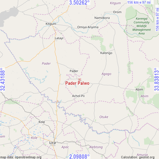
Pader Palwo GPS coordinates[2]
2° 48' 2.016" North, 33° 8' 6" East
| Map corner | latitude | longitude |
|---|---|---|
| Upper-left | 3.50262°, | 32.43188° |
| Center: | 2.80056°, | 33.135° |
| Lower-right: | 2.09808°, | 33.83813° |
| Map W x H: | 156.2×156.2 km | = 97.1×97.1mi |
| max Lat: | 3.66088° ⇑8.9% North |
| Pader Palwo: | 2.80056° |
| min Lat: | ⇓91.1% South -1.28538° |
| min Long | Pader Palwo | max Long |
| 29.65° | 33.135° | 34.95° |
| W 65.8%⇐ | ⇒34.2% E |
Elevation
Elevation of Pader Palwo is 1034 m = 3392 ft, and this is 225 m = 738 ft below average elevation for this country.
| Max E: |
4129 m = 13547 ft | 92.5% |
| Avg. | 1259 m = 4131 ft | |
| Pader Palwo | 1034 m = 3392 ft | |
Min E: |
622 m = 2041 ft | 7.5% |
See also: Uganda elevation on elevation.city.
Geographical zone
Pader Palwo is located in North Torrid zone (between Equator and Tropic of Cancer). Distance of Equator is 311.4 km =193.5 mi to South.| Distance of | km | miles | from Pader Palwo |
|---|---|---|---|
| North Pole | 9695.7 | 6024.6 | to North |
| Arctic Circle | 7089.8 | 4405.4 | to North |
| Tropic Cancer | 2294.5 | 1425.7 | to North |
| Equator | 311.4 | 193.5 | to South |


Nearby cities:
15 places around Pader Palwo: (largest is in red/bold)
• Abim
61.1 km =38 mi,  100°
100°
• Agago
22.4 km =13.9 mi,  80°
80°
• Alebtong
63.2 km =39.3 mi,  167°
167°
• Amuria
105.5 km =65.6 mi,  147°
147°
• Apac
113.2 km =70.3 mi,  215°
215°
• Dokolo
100.4 km =62.4 mi,  177°
177°
• Gulu
92.9 km =57.7 mi,  268°
268°
• Kitgum
59.9 km =37.2 mi,  332°
332°
• Kole
58 km =36 mi, 219°
• Kotido
112.6 km =70 mi, 79°
• Lamwo
89.1 km =55.4 mi,  335°
335°
• Lira
66.6 km =41.4 mi,  203°
203°
• Otuke
52.6 km =32.7 mi,  129°
129°
• Oyam
104.4 km =64.9 mi,  232°
232°
• Pader
29.2 km =18.1 mi,  18°
18°
Sources, notices
• [Note1] Compared only with cities in Uganda existing in our database
• [Src1] Map data: © OpenStreetMap contributors (CC-BY-SA)
• [Src2] Other city data from geonames.org with taken over terms of usage.
• [Src3] Geographical zone / Annual Mean Temperature by Robert A. Rohde @ Wikipedia
