Oyam geodata
Oyam (Northern Region) is a seat of a second-order administrative division; located in Uganda in Africa/Kampala (GMT+3) time zone. In our database, there are 80 cities with bigger population. Compared to other cities in Uganda, 82.2% of cities are located further ↓South; 52.1% of cities are located further →East and 88.4% of cities have higher elevation than Oyam. Note1
Administrative division(s):
- Level 1: Northern Region
- Level 2: Oyam District
- Level 3: Oyam County
- Level 4: Aber


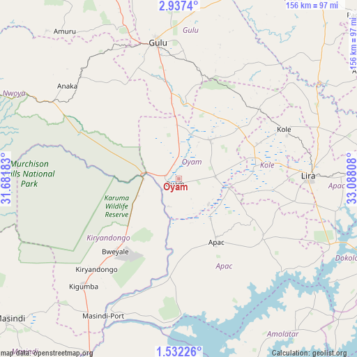
Oyam GPS coordinates[2]
2° 14' 6" North, 32° 23' 5.82" East
| Map corner | latitude | longitude |
|---|---|---|
| Upper-left | 2.9374°, | 31.68183° |
| Center: | 2.235°, | 32.38495° |
| Lower-right: | 1.53226°, | 33.08808° |
| Map W x H: | 156.2×156.2 km | = 97.1×97.1mi |
| max Lat: | 3.66088° ⇑17.8% North |
| Oyam: | 2.235° |
| min Lat: | ⇓82.2% South -1.28538° |
| min Long | Oyam | max Long |
| 29.65° | 32.38495° | 34.95° |
| W 47.9%⇐ | ⇒52.1% E |
Elevation
Elevation of Oyam is 1053 m = 3455 ft, and this is 206 m = 676 ft below average elevation for this country.
| Max E: |
4129 m = 13547 ft | 88.4% |
| Avg. | 1259 m = 4131 ft | |
| Oyam | 1053 m = 3455 ft | |
Min E: |
622 m = 2041 ft | 11.6% |
See also: Uganda elevation on elevation.city.
Geographical zone
Oyam is located in North Torrid zone (between Equator and Tropic of Cancer). Distance of Equator is 248.5 km =154.4 mi to South.| Distance of | km | miles | from Oyam |
|---|---|---|---|
| North Pole | 9758.6 | 6063.7 | to North |
| Arctic Circle | 7152.7 | 4444.5 | to North |
| Tropic Cancer | 2357.4 | 1464.8 | to North |
| Equator | 248.5 | 154.4 | to South |


Nearby cities:
15 places around Oyam: (largest is in red/bold)
• Alebtong
96.6 km =60 mi,  89°
89°
• Amolatar
85.4 km =53.1 mi,  143°
143°
• Amuru
81.2 km =50.5 mi,  322°
322°
• Apac
33.5 km =20.8 mi,  149°
149°
• Dokolo
95.7 km =59.5 mi,  113°
113°
• Gulu
60.7 km =37.7 mi,  350°
350°
• Kaberamaido
102.2 km =63.5 mi,  122°
122°
• Kiryandongo
53.6 km =33.3 mi,  221°
221°
• Kole
49.7 km =30.9 mi,  68°
68°
• Lira
57.2 km =35.5 mi, 88°
• Masindi
97.1 km =60.3 mi,  230°
230°
• Masindi Port
68.5 km =42.6 mi,  208°
208°
• Nakasongola
103.3 km =64.2 mi,  175°
175°
• Nwoya
61.6 km =38.3 mi, 316°
• Pader Palwo
104.4 km =64.9 mi,  52°
52°
Sources, notices
• [Note1] Compared only with cities in Uganda existing in our database
• [Src1] Map data: © OpenStreetMap contributors (CC-BY-SA)
• [Src2] Other city data from geonames.org with taken over terms of usage.
• [Src3] Geographical zone / Annual Mean Temperature by Robert A. Rohde @ Wikipedia
