Chui geodata
Chui (Rocha) is a populated place; located in Uruguay in America/Montevideo (GMT-3) time zone. With population of 10,485 people, there are 35 cities with bigger population in this country. Compared to other cities in Uruguay, 57.4% of cities are located further ↓South; 99.2% of cities are located further ←West and 84.4% of cities have higher elevation than Chui. Note1


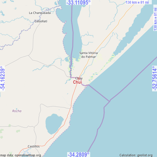
Chui GPS coordinates[2]
33° 41' 52.512" South, 53° 27' 33.336" West
| Map corner | latitude | longitude |
|---|---|---|
| Upper-left | -33.11095°, | -54.16239° |
| Center: | -33.69792°, | -53.45926° |
| Lower-right: | -34.2809°, | -52.75614° |
| Map W x H: | 130.1×130.1 km | = 80.8×80.8mi |
| max Lat: | -30.25966° ⇑42.6% North |
| Chui: | -33.69792° |
| min Lat: | ⇓57.4% South -34.94747° |
| min Long | Chui | max Long |
| -58.41176° | -53.45926° | -53.38583° |
| W 99.2%⇐ | ⇒0.8% E |
Elevation
Elevation of Chui is 16 m = 52 ft, and this is 54.6 m = 179 ft below average elevation for this country.
| Max E: |
294 m = 965 ft | 84.4% |
| Avg. | 70.6 m = 232 ft | |
| Chui | 16 m = 52 ft | |
Min E: |
2 m = 7 ft | 15.6% |
See also: Uruguay elevation on elevation.city.
Geographical zone
Chui is located in South temperate zone (between Tropic of Capricorn and the Antarctic Circle). Distance of this Southern Tropic circle is 1140.9 km =708.9 mi to North.| Distance of | km | miles | from Chui |
|---|---|---|---|
| Equator | 3746.9 | 2328.2 | to North |
| Tropic Capricorn | 1140.9 | 708.9 | to North |
| Antarctic Circle | 3654.3 | 2270.7 | to South |
| South Pole | 6260.2 | 3889.9 | to South |


Nearby cities:
15 places around Chui: (largest is in red/bold)
• Aiguá
132.3 km =82.2 mi,  244°
244°
• Castillos
66.8 km =41.5 mi,  213°
213°
• Cebollatí
57.1 km =35.5 mi,  327°
327°
• Dieciocho de Julio
8.9 km =5.5 mi,  281°
281°
• José Pedro Varela
103.3 km =64.2 mi,  285°
285°
• La Paloma
125.4 km =77.9 mi, 211°
• Lascano
69.2 km =43 mi,  272°
272°
• Mariscala
127.5 km =79.2 mi,  252°
252°
• Rocha
118.8 km =73.8 mi,  222°
222°
• Río Branco
122.5 km =76.1 mi,  3°
3°
• Treinta y Tres
100.1 km =62.2 mi,  301°
301°
• Tupambaé
155 km =96.3 mi,  308°
308°
• Velázquez
84.6 km =52.6 mi, 243°
• Vergara
94.9 km =59 mi, 332°
• Villa Sara
101.9 km =63.3 mi, 299°
Sources, notices
• [Note1] Compared only with cities in Uruguay existing in our database
• [Src1] Map data: © OpenStreetMap contributors (CC-BY-SA)
• [Src2] Other city data from geonames.org with taken over terms of usage.
• [Src3] Geographical zone / Annual Mean Temperature by Robert A. Rohde @ Wikipedia
