José Batlle y Ordóñez geodata
José Batlle y Ordóñez (Lavalleja) is a populated place; located in Uruguay in America/Montevideo (GMT-3) time zone. With population of 2,438 people, there are 80 cities with bigger population in this country. Compared to other cities in Uruguay, 63.1% of cities are located further ↓South; 80.3% of cities are located further ←West and 99.2% of cities have lower elevation than José Batlle y Ordóñez. Note1


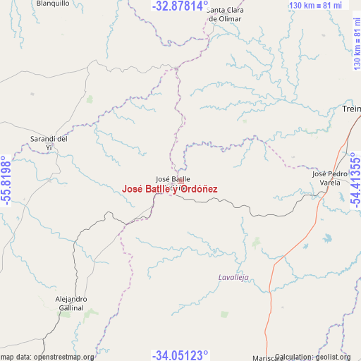
José Batlle y Ordóñez GPS coordinates[2]
33° 28' 0.012" South, 55° 7' 0.012" West
| Map corner | latitude | longitude |
|---|---|---|
| Upper-left | -32.87814°, | -55.8198° |
| Center: | -33.46667°, | -55.11667° |
| Lower-right: | -34.05123°, | -54.41355° |
| Map W x H: | 130.4×130.4 km | = 81×81mi |
| max Lat: | -30.25966° ⇑36.9% North |
| José Batlle y Ordóñez: | -33.46667° |
| min Lat: | ⇓63.1% South -34.94747° |
| min Long | José Batlle y | max Long |
| -58.41176° | -55.11667° | -53.38583° |
| W 80.3%⇐ | ⇒19.7% E |
Elevation
Elevation of José Batlle y Ordóñez is 293 m = 961 ft, and this is 222.4 m = 730 ft above average elevation for this country.
| Max E: |
294 m = 965 ft | 0.8% |
| José Batlle y Ordóñez | 293 m 961 ft | |
| Avg. | 70.6 m = 232 ft | |
Min E: |
2 m = 7 ft | 99.2% |
See also: Uruguay elevation on elevation.city.
Geographical zone
José Batlle y Ordóñez is located in South temperate zone (between Tropic of Capricorn and the Antarctic Circle). Distance of this Southern Tropic circle is 1115.2 km =693 mi to North.| Distance of | km | miles | from José Batlle y Ordóñez |
|---|---|---|---|
| Equator | 3721.1 | 2312.2 | to North |
| Tropic Capricorn | 1115.2 | 693 | to North |
| Antarctic Circle | 3680 | 2286.6 | to South |
| South Pole | 6285.9 | 3905.9 | to South |


Nearby cities:
15 places around José Batlle y Ordóñez: (largest is in red/bold)
• Aiguá
88.6 km =55.1 mi,  157°
157°
• Alejandro Gallinal
59.1 km =36.7 mi,  221°
221°
• Blanquillo
91.5 km =56.9 mi,  328°
328°
• Casupá
85.8 km =53.3 mi,  214°
214°
• José Pedro Varela
53.9 km =33.5 mi,  88°
88°
• La Paloma
93 km =57.8 mi, 332°
• Lascano
87.4 km =54.3 mi,  105°
105°
• Mariscala
71.1 km =44.2 mi,  153°
153°
• Santa Clara de Olimar
62.6 km =38.9 mi,  14°
14°
• Sarandí del Yi
49.7 km =30.9 mi,  285°
285°
• Treinta y Tres
72.9 km =45.3 mi,  69°
69°
• Tupambaé
77.6 km =48.2 mi,  24°
24°
• Velázquez
99.9 km =62.1 mi,  129°
129°
• Villa Sara
69 km =42.9 mi, 69°
• Villa del Carmen
86.7 km =53.9 mi, 286°
Sources, notices
• [Note1] Compared only with cities in Uruguay existing in our database
• [Src1] Map data: © OpenStreetMap contributors (CC-BY-SA)
• [Src2] Other city data from geonames.org with taken over terms of usage.
• [Src3] Geographical zone / Annual Mean Temperature by Robert A. Rohde @ Wikipedia
