Lascano geodata
Lascano (Rocha) is a populated place; located in Uruguay in America/Montevideo (GMT-3) time zone. With population of 6,976 people, there are 48 cities with bigger population in this country. Compared to other cities in Uruguay, 59.8% of cities are located further ↓South; 91.8% of cities are located further ←West and 56.6% of cities have higher elevation than Lascano. Note1


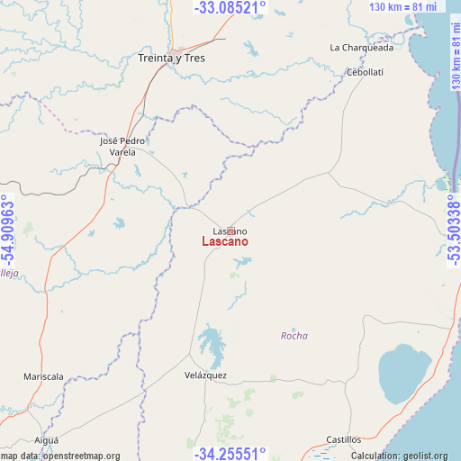
Lascano GPS coordinates[2]
33° 40' 20.46" South, 54° 12' 23.4" West
| Map corner | latitude | longitude |
|---|---|---|
| Upper-left | -33.08521°, | -54.90963° |
| Center: | -33.67235°, | -54.2065° |
| Lower-right: | -34.25551°, | -53.50338° |
| Map W x H: | 130.1×130.1 km | = 80.8×80.8mi |
| max Lat: | -30.25966° ⇑40.2% North |
| Lascano: | -33.67235° |
| min Lat: | ⇓59.8% South -34.94747° |
| min Long | Lascano | max Long |
| -58.41176° | -54.2065° | -53.38583° |
| W 91.8%⇐ | ⇒8.2% E |
Elevation
Elevation of Lascano is 45 m = 148 ft, and this is 25.6 m = 84 ft below average elevation for this country.
| Max E: |
294 m = 965 ft | 56.6% |
| Avg. | 70.6 m = 232 ft | |
| Lascano | 45 m = 148 ft | |
Min E: |
2 m = 7 ft | 43.4% |
See also: Uruguay elevation on elevation.city.
Geographical zone
Lascano is located in South temperate zone (between Tropic of Capricorn and the Antarctic Circle). Distance of this Southern Tropic circle is 1138.1 km =707.2 mi to North.| Distance of | km | miles | from Lascano |
|---|---|---|---|
| Equator | 3744 | 2326.4 | to North |
| Tropic Capricorn | 1138.1 | 707.2 | to North |
| Antarctic Circle | 3657.2 | 2272.5 | to South |
| South Pole | 6263 | 3891.6 | to South |


Nearby cities:
15 places around Lascano: (largest is in red/bold)
• Aiguá
78 km =48.5 mi,  220°
220°
• Castillos
66.7 km =41.4 mi,  151°
151°
• Cebollatí
59.1 km =36.7 mi,  40°
40°
• Chui
69.2 km =43 mi,  92°
92°
• Dieciocho de Julio
60.5 km =37.6 mi, 91°
• José Batlle y Ordóñez
87.4 km =54.3 mi,  285°
285°
• José Pedro Varela
39 km =24.2 mi,  308°
308°
• Mariscala
66.8 km =41.5 mi,  232°
232°
• Rocha
90.9 km =56.5 mi,  187°
187°
• Santa Clara de Olimar
108 km =67.1 mi,  320°
320°
• Treinta y Tres
51.5 km =32 mi,  341°
341°
• Tupambaé
106.8 km =66.4 mi,  330°
330°
• Velázquez
41 km =25.5 mi, 189°
• Vergara
84.7 km =52.6 mi,  17°
17°
• Villa Sara
50.6 km =31.4 mi, 337°
Sources, notices
• [Note1] Compared only with cities in Uruguay existing in our database
• [Src1] Map data: © OpenStreetMap contributors (CC-BY-SA)
• [Src2] Other city data from geonames.org with taken over terms of usage.
• [Src3] Geographical zone / Annual Mean Temperature by Robert A. Rohde @ Wikipedia
