Tirmiz geodata
Tirmiz (Surxondaryo) is a seat of a first-order administrative division; located in Uzbekistan in Asia/Samarkand (GMT+5) time zone. With population of 140,385 people, there are 12 cities with bigger population in this country. Compared to other cities in Uzbekistan, 100% of cities are located further ↑North; 50% of cities are located further ←West and 69.5% of cities have higher elevation than Tirmiz. Note1


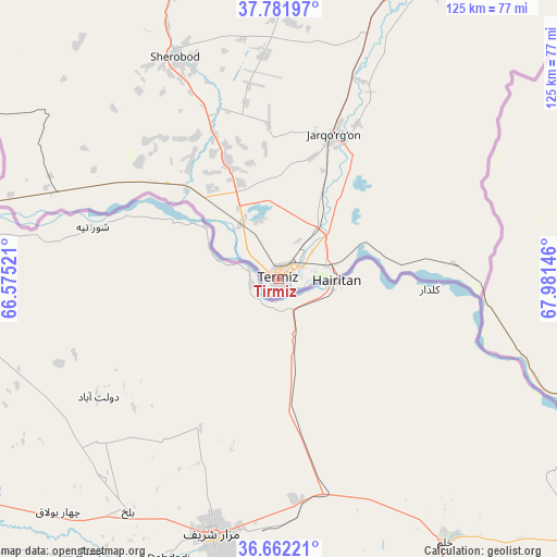
Tirmiz GPS coordinates[2]
37° 13' 27.012" North, 67° 16' 41.988" East
| Map corner | latitude | longitude |
|---|---|---|
| Upper-left | 37.78197°, | 66.57521° |
| Center: | 37.22417°, | 67.27833° |
| Lower-right: | 36.66221°, | 67.98146° |
| Map W x H: | 124.5×124.5 km | = 77.4×77.4mi |
| max Lat: | 43.77877° ⇑100% North |
| Tirmiz: | 37.22417° |
| min Lat: | ⇓0% South 37.22417° |
| min Long | Tirmiz | max Long |
| 58.84596° | 67.27833° | 72.76177° |
| W 50%⇐ | ⇒50% E |
Elevation
Elevation of Tirmiz is 304 m = 997 ft, and this is 129.8 m = 426 ft below average elevation for this country.
| Max E: |
1464 m = 4803 ft | 69.5% |
| Avg. | 433.8 m = 1423 ft | |
| Tirmiz | 304 m = 997 ft | |
Min E: |
50 m = 164 ft | 30.5% |
See also: Tirmiz elevation on elevation.city.
Geographical zone
Tirmiz is located in North temperate zone (between Tropic of Cancer and the Arctic Circle). Distance of this Northern Tropic circle is 1533 km =952.6 mi to South.| Distance of | km | miles | from Tirmiz |
|---|---|---|---|
| North Pole | 5868.1 | 3646.3 | to North |
| Arctic Circle | 3262.2 | 2027 | to North |
| Tropic Cancer | 1533 | 952.6 | to South |
| Equator | 4138.9 | 2571.8 | to South |


Nearby cities:
15 places around Tirmiz: (largest is in red/bold)
• Boysun
109.6 km =68.1 mi,  356°
356°
• Chiroqchi
210.5 km =130.8 mi,  342°
342°
• Chiroqchi Shahri
209.6 km =130.2 mi, 343°
• Denov
128.2 km =79.7 mi,  25°
25°
• G‘uzor
179.7 km =111.7 mi,  329°
329°
• G‘uzor Shahri
180.3 km =112 mi, 329°
• Kitob
210.5 km =130.8 mi,  349°
349°
• Kitob Shahri
214 km =133 mi, 350°
• Qamashi Shahri
191.2 km =118.8 mi, 338°
• Qorashina
139.3 km =86.6 mi, 333°
• Shahrisabz
207.5 km =128.9 mi, 349°
• Shahrisabz Shahri
207.1 km =128.7 mi, 348°
• Sho‘rchi
97.2 km =60.4 mi, 27°
• Yakkabog‘ Shahri
201.6 km =125.3 mi, 345°
• Yangi-Nishon Shahri
210.6 km =130.9 mi,  318°
318°
Sources, notices
• [Note1] Compared only with cities in Uzbekistan existing in our database
• [Src1] Map data: © OpenStreetMap contributors (CC-BY-SA)
• [Src2] Other city data from geonames.org with taken over terms of usage.
• [Src3] Geographical zone / Annual Mean Temperature by Robert A. Rohde @ Wikipedia
