Boysun geodata
Boysun (Surxondaryo) is a populated place; located in Uzbekistan in Asia/Samarkand (GMT+5) time zone. With population of 25,050 people, there are 67 cities with bigger population in this country. Compared to other cities in Uzbekistan, 98.9% of cities are located further ↑North; 51.7% of cities are located further →East and 98.3% of cities have lower elevation than Boysun. Note1


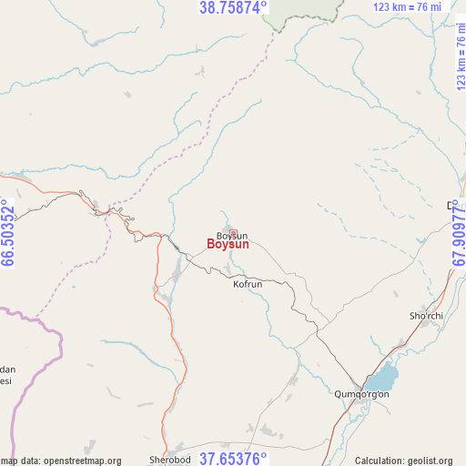
Boysun GPS coordinates[2]
38° 12' 30.06" North, 67° 12' 23.904" East
| Map corner | latitude | longitude |
|---|---|---|
| Upper-left | 38.75874°, | 66.50352° |
| Center: | 38.20835°, | 67.20664° |
| Lower-right: | 37.65376°, | 67.90977° |
| Map W x H: | 122.9×122.9 km | = 76.4×76.4mi |
| max Lat: | 43.77877° ⇑98.9% North |
| Boysun: | 38.20835° |
| min Lat: | ⇓1.1% South 37.22417° |
| min Long | Boysun | max Long |
| 58.84596° | 67.20664° | 72.76177° |
| W 48.3%⇐ | ⇒51.7% E |
Elevation
Elevation of Boysun is 1240 m = 4068 ft, and this is 806.2 m = 2645 ft above average elevation for this country.
| Max E: |
1464 m = 4803 ft | 1.7% |
| Boysun | 1240 m 4068 ft | |
| Avg. | 433.8 m = 1423 ft | |
Min E: |
50 m = 164 ft | 98.3% |
See also: Uzbekistan elevation on elevation.city.
Geographical zone
Boysun is located in North temperate zone (between Tropic of Cancer and the Arctic Circle). Distance of this Northern Tropic circle is 1642.5 km =1020.6 mi to South.| Distance of | km | miles | from Boysun |
|---|---|---|---|
| North Pole | 5758.7 | 3578.3 | to North |
| Arctic Circle | 3152.8 | 1959.1 | to North |
| Tropic Cancer | 1642.5 | 1020.6 | to South |
| Equator | 4248.4 | 2639.8 | to South |


Nearby cities:
15 places around Boysun: (largest is in red/bold)
• Chiroqchi
107 km =66.5 mi,  329°
329°
• Chiroqchi Shahri
106.1 km =65.9 mi, 329°
• Denov
60.8 km =37.8 mi,  83°
83°
• G‘uzor
95.3 km =59.2 mi,  298°
298°
• G‘uzor Shahri
95.8 km =59.5 mi, 299°
• Kitob
102.6 km =63.8 mi,  341°
341°
• Kitob Shahri
105.6 km =65.6 mi, 344°
• Qamashi Shahri
93.8 km =58.3 mi,  316°
316°
• Qorashina
58.1 km =36.1 mi,  284°
284°
• Shahrisabz
99.8 km =62 mi, 341°
• Shahrisabz Shahri
99.6 km =61.9 mi, 340°
• Sho‘rchi
55.9 km =34.7 mi,  114°
114°
• Tirmiz
109.6 km =68.1 mi,  176°
176°
• Urgut
132.8 km =82.5 mi,  1°
1°
• Yakkabog‘ Shahri
96.6 km =60 mi, 332°
Sources, notices
• [Note1] Compared only with cities in Uzbekistan existing in our database
• [Src1] Map data: © OpenStreetMap contributors (CC-BY-SA)
• [Src2] Other city data from geonames.org with taken over terms of usage.
• [Src3] Geographical zone / Annual Mean Temperature by Robert A. Rohde @ Wikipedia
