Sho‘rchi geodata
Sho‘rchi (Surxondaryo) is a populated place; located in Uzbekistan in Asia/Samarkand (GMT+5) time zone. With population of 24,900 people, there are 69 cities with bigger population in this country. Compared to other cities in Uzbekistan, 99.4% of cities are located further ↑North; 50.6% of cities are located further ←West and 56.3% of cities have lower elevation than Sho‘rchi. Note1


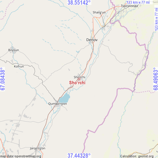
Sho‘rchi GPS coordinates[2]
37° 59' 57.984" North, 67° 47' 15" East
| Map corner | latitude | longitude |
|---|---|---|
| Upper-left | 38.55142°, | 67.08438° |
| Center: | 37.99944°, | 67.7875° |
| Lower-right: | 37.44328°, | 68.49063° |
| Map W x H: | 123.2×123.2 km | = 76.6×76.6mi |
| max Lat: | 43.77877° ⇑99.4% North |
| Sho‘rchi: | 37.99944° |
| min Lat: | ⇓0.6% South 37.22417° |
| min Long | Sho‘rchi | max Long |
| 58.84596° | 67.7875° | 72.76177° |
| W 50.6%⇐ | ⇒49.4% E |
Elevation
Elevation of Sho‘rchi is 450 m = 1476 ft, and this is 16.2 m = 53 ft above average elevation for this country.
| Max E: |
1464 m = 4803 ft | 43.7% |
| Sho‘rchi | 450 m 1476 ft | |
| Avg. | 433.8 m = 1423 ft | |
Min E: |
50 m = 164 ft | 56.3% |
See also: Uzbekistan elevation on elevation.city.
Geographical zone
Sho‘rchi is located in North temperate zone (between Tropic of Cancer and the Arctic Circle). Distance of this Northern Tropic circle is 1619.2 km =1006.1 mi to South.| Distance of | km | miles | from Sho‘rchi |
|---|---|---|---|
| North Pole | 5781.9 | 3592.7 | to North |
| Arctic Circle | 3176 | 1973.5 | to North |
| Tropic Cancer | 1619.2 | 1006.1 | to South |
| Equator | 4225.1 | 2625.4 | to South |


Nearby cities:
15 places around Sho‘rchi: (largest is in red/bold)
• Boysun
55.9 km =34.7 mi,  294°
294°
• Chiroqchi
156.2 km =97.1 mi,  317°
317°
• Chiroqchi Shahri
155.2 km =96.4 mi, 317°
• Denov
31.4 km =19.5 mi,  18°
18°
• G‘uzor
151 km =93.8 mi,  297°
297°
• G‘uzor Shahri
151.5 km =94.1 mi, 297°
• Kitob
146.4 km =91 mi,  325°
325°
• Kitob Shahri
147.9 km =91.9 mi, 327°
• Qamashi Shahri
147 km =91.3 mi,  308°
308°
• Qorashina
113.6 km =70.6 mi, 289°
• Shahrisabz
144 km =89.5 mi, 324°
• Shahrisabz Shahri
144.1 km =89.5 mi, 324°
• Tirmiz
97.2 km =60.4 mi,  207°
207°
• Urgut
163 km =101.3 mi,  343°
343°
• Yakkabog‘ Shahri
144.7 km =89.9 mi, 318°
Sources, notices
• [Note1] Compared only with cities in Uzbekistan existing in our database
• [Src1] Map data: © OpenStreetMap contributors (CC-BY-SA)
• [Src2] Other city data from geonames.org with taken over terms of usage.
• [Src3] Geographical zone / Annual Mean Temperature by Robert A. Rohde @ Wikipedia
