Guayabal geodata
Guayabal (Guárico) is a seat of a second-order administrative division; located in Venezuela in America/Caracas (GMT-4) time zone. In our database, there are 108 cities with bigger population. Compared to other cities in Venezuela, 87.5% of cities are located further ↑North; 65.6% of cities are located further ←West and 78.4% of cities have higher elevation than Guayabal. Note1


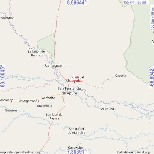
Guayabal GPS coordinates[2]
8° 0' 2.772" North, 67° 23' 50.352" West
| Map corner | latitude | longitude |
|---|---|---|
| Upper-left | 8.69644°, | -68.10045° |
| Center: | 8.00077°, | -67.39732° |
| Lower-right: | 7.30391°, | -66.6942° |
| Map W x H: | 154.8×154.8 km | = 96.2×96.2mi |
| max Lat: | 11.94788° ⇑87.5% North |
| Guayabal: | 8.00077° |
| min Lat: | ⇓12.5% South 1.92027° |
| min Long | Guayabal | max Long |
| -72.55212° | -67.39732° | -60.99778° |
| W 65.6%⇐ | ⇒34.4% E |
Elevation
Elevation of Guayabal is 56 m = 184 ft, and this is 324.6 m = 1065 ft below average elevation for this country.
| Max E: |
2986 m = 9797 ft | 78.4% |
| Avg. | 380.6 m = 1249 ft | |
| Guayabal | 56 m = 184 ft | |
Min E: |
-4 m = -13 ft | 21.6% |
See also: Venezuela elevation on elevation.city.
Geographical zone
Guayabal is located in North Torrid zone (between Equator and Tropic of Cancer). Distance of Equator is 889.6 km =552.8 mi to South.| Distance of | km | miles | from Guayabal |
|---|---|---|---|
| North Pole | 9117.5 | 5665.4 | to North |
| Arctic Circle | 6511.6 | 4046.1 | to North |
| Tropic Cancer | 1716.3 | 1066.5 | to North |
| Equator | 889.6 | 552.8 | to South |


Nearby cities:
15 places around Guayabal: (largest is in red/bold)
• Achaguas
94.3 km =58.6 mi,  254°
254°
• Arismendi
119.5 km =74.3 mi,  296°
296°
• Biruaca
21.8 km =13.5 mi,  217°
217°
• Caicara del Orinoco
141.4 km =87.9 mi,  106°
106°
• Calabozo
102.7 km =63.8 mi,  358°
358°
• Camaguán
26 km =16.2 mi, 297°
• El Baúl
145.5 km =90.4 mi,  317°
317°
• El Sombrero
158.5 km =98.5 mi,  13°
13°
• Guadarrama
93.1 km =57.8 mi,  309°
309°
• La Unión
47.1 km =29.3 mi, 300°
• Las Mercedes
165.4 km =102.8 mi,  41°
41°
• Palmasola
156.1 km =97 mi,  28°
28°
• San Antonio
114.2 km =71 mi,  267°
267°
• San Fernando de Apure
15 km =9.3 mi,  213°
213°
• San Juan de Payara
45.7 km =28.4 mi, 210°
Sources, notices
• [Note1] Compared only with cities in Venezuela existing in our database
• [Src1] Map data: © OpenStreetMap contributors (CC-BY-SA)
• [Src2] Other city data from geonames.org with taken over terms of usage.
• [Src3] Geographical zone / Annual Mean Temperature by Robert A. Rohde @ Wikipedia
