Biruaca geodata
Biruaca (Apure) is a seat of a second-order administrative division; located in Venezuela in America/Caracas (GMT-4) time zone. In our database, there are 108 cities with bigger population. Compared to other cities in Venezuela, 90.3% of cities are located further ↑North; 63.6% of cities are located further ←West and 79.9% of cities have higher elevation than Biruaca. Note1


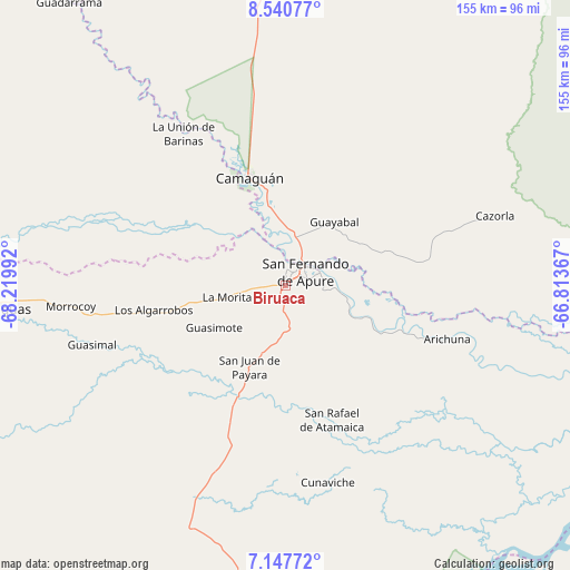
Biruaca GPS coordinates[2]
7° 50' 41.388" North, 67° 31' 0.444" West
| Map corner | latitude | longitude |
|---|---|---|
| Upper-left | 8.54077°, | -68.21992° |
| Center: | 7.84483°, | -67.51679° |
| Lower-right: | 7.14772°, | -66.81367° |
| Map W x H: | 154.9×154.9 km | = 96.3×96.3mi |
| max Lat: | 11.94788° ⇑90.3% North |
| Biruaca: | 7.84483° |
| min Lat: | ⇓9.7% South 1.92027° |
| min Long | Biruaca | max Long |
| -72.55212° | -67.51679° | -60.99778° |
| W 63.6%⇐ | ⇒36.4% E |
Elevation
Elevation of Biruaca is 51 m = 167 ft, and this is 329.6 m = 1081 ft below average elevation for this country.
| Max E: |
2986 m = 9797 ft | 79.9% |
| Avg. | 380.6 m = 1249 ft | |
| Biruaca | 51 m = 167 ft | |
Min E: |
-4 m = -13 ft | 20.1% |
See also: Venezuela elevation on elevation.city.
Geographical zone
Biruaca is located in North Torrid zone (between Equator and Tropic of Cancer). Distance of Equator is 872.3 km =542 mi to South.| Distance of | km | miles | from Biruaca |
|---|---|---|---|
| North Pole | 9134.8 | 5676.1 | to North |
| Arctic Circle | 6528.9 | 4056.9 | to North |
| Tropic Cancer | 1733.7 | 1077.3 | to North |
| Equator | 872.3 | 542 | to South |


Nearby cities:
15 places around Biruaca: (largest is in red/bold)
• Achaguas
78.2 km =48.6 mi,  264°
264°
• Arismendi
117.5 km =73 mi,  306°
306°
• Caicara del Orinoco
150.4 km =93.5 mi,  98°
98°
• Calabozo
120.4 km =74.8 mi,  4°
4°
• Camaguán
30.8 km =19.1 mi,  341°
341°
• El Baúl
150.9 km =93.8 mi,  325°
325°
• El Sombrero
178.7 km =111 mi,  16°
16°
• Guadarrama
96.6 km =60 mi,  322°
322°
• Guayabal
21.8 km =13.5 mi,  37°
37°
• La Unión
49.6 km =30.8 mi, 326°
• Palmasola
177.7 km =110.4 mi,  29°
29°
• San Antonio
101.9 km =63.3 mi,  277°
277°
• San Fernando de Apure
6.8 km =4.2 mi,  45°
45°
• San Juan de Payara
24.2 km =15 mi,  204°
204°
• Santa Catalina
154.5 km =96 mi,  273°
273°
Sources, notices
• [Note1] Compared only with cities in Venezuela existing in our database
• [Src1] Map data: © OpenStreetMap contributors (CC-BY-SA)
• [Src2] Other city data from geonames.org with taken over terms of usage.
• [Src3] Geographical zone / Annual Mean Temperature by Robert A. Rohde @ Wikipedia
