San Fernando de Apure geodata
San Fernando de Apure (Apure) is a seat of a first-order administrative division; located in Venezuela in America/Caracas (GMT-4) time zone. With population of 78,779 people, there are 52 cities with bigger population in this country. Compared to other cities in Venezuela, 89.8% of cities are located further ↑North; 64.6% of cities are located further ←West and 79.9% of cities have higher elevation than San Fernando de Apure. Note1
Current local time in San Fernando de Apure:
01:50 PM, ThursdayDifference from your time zone: hours


San Fernando de Apure GPS coordinates[2]
7° 53' 16.152" North, 67° 28' 20.496" West
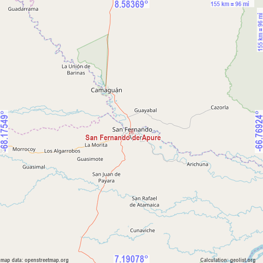
| Map corner | latitude | longitude |
|---|---|---|
| Upper-left | 8.58369°, | -68.17549° |
| Center: | 7.88782°, | -67.47236° |
| Lower-right: | 7.19078°, | -66.76924° |
| Map W x H: | 154.9×154.9 km | = 96.3×96.3mi |
| max Lat: | 11.94788° ⇑89.8% North |
| San Fernando de Apure: | 7.88782° |
| min Lat: | ⇓10.2% South 1.92027° |
| min Long | San Fernando de | max Long |
| -72.55212° | -67.47236° | -60.99778° |
| W 64.6%⇐ | ⇒35.4% E |
Elevation
Elevation of San Fernando de Apure is 51 m = 167 ft, and this is 329.6 m = 1081 ft below average elevation for this country.
| Max E: |
2986 m = 9797 ft | 79.9% |
| Avg. | 380.6 m = 1249 ft | |
| San Fernando de Apure | 51 m = 167 ft | |
Min E: |
-4 m = -13 ft | 20.1% |
See also: San Fernando de Apure elevation on elevation.city.
Geographical zone
San Fernando de Apure is located in North Torrid zone (between Equator and Tropic of Cancer). Distance of Equator is 877 km =544.9 mi to South.| Distance of | km | miles | from San Fernando de Apure |
|---|---|---|---|
| North Pole | 9130 | 5673.1 | to North |
| Arctic Circle | 6524.1 | 4053.9 | to North |
| Tropic Cancer | 1728.9 | 1074.3 | to North |
| Equator | 877 | 544.9 | to South |


Nearby cities:
15 places around San Fernando de Apure: (largest is in red/bold)
• Achaguas
83.6 km =51.9 mi,  261°
261°
• Arismendi
118.7 km =73.8 mi,  303°
303°
• Biruaca
6.8 km =4.2 mi,  225°
225°
• Caicara del Orinoco
146.4 km =91 mi,  101°
101°
• Calabozo
115.3 km =71.6 mi,  2°
2°
• Camaguán
28.6 km =17.8 mi,  328°
328°
• El Baúl
149.9 km =93.1 mi,  322°
322°
• El Sombrero
172.7 km =107.3 mi,  15°
15°
• Guadarrama
96 km =59.7 mi, 318°
• Guayabal
15 km =9.3 mi,  33°
33°
• La Unión
48.8 km =30.3 mi, 318°
• Palmasola
171.1 km =106.3 mi, 29°
• San Antonio
106.2 km =66 mi,  274°
274°
• San Juan de Payara
30.7 km =19.1 mi,  208°
208°
• Santa Catalina
159.2 km =98.9 mi, 271°
Sources, notices
• [Note1] Compared only with cities in Venezuela existing in our database
• [Src1] Map data: © OpenStreetMap contributors (CC-BY-SA)
• [Src2] Other city data from geonames.org with taken over terms of usage.
• [Src3] Geographical zone / Annual Mean Temperature by Robert A. Rohde @ Wikipedia
