Aţ Ţalḩ geodata
Aţ Ţalḩ (Shabwah) is a seat of a second-order administrative division; located in Yemen in Asia/Aden (GMT+3) time zone. In our database, there are 51 cities with bigger population. Compared to other cities in Yemen, 55.5% of cities are located further ↓South; 85.4% of cities are located further ←West and 54.2% of cities have lower elevation than Aţ Ţalḩ. Note1


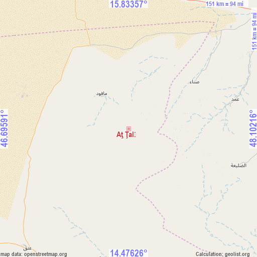
Aţ Ţalḩ GPS coordinates[2]
15° 9' 21.6" North, 47° 23' 56.508" East
| Map corner | latitude | longitude |
|---|---|---|
| Upper-left | 15.83357°, | 46.69591° |
| Center: | 15.156°, | 47.39903° |
| Lower-right: | 14.47626°, | 48.10216° |
| Map W x H: | 150.9×150.9 km | = 93.8×93.8mi |
| max Lat: | 17.76999° ⇑44.5% North |
| Aţ Ţalḩ: | 15.156° |
| min Lat: | ⇓55.5% South 12.18576° |
| min Long | Aţ Ţalḩ | max Long |
| 42.67107° | 47.39903° | 54.01895° |
| W 85.4%⇐ | ⇒14.6% E |
Elevation
Elevation of Aţ Ţalḩ is 1398 m = 4587 ft, and this is 93.2 m = 306 ft above average elevation for this country.
| Max E: |
2791 m = 9157 ft | 45.8% |
| Aţ Ţalḩ | 1398 m 4587 ft | |
| Avg. | 1304.8 m = 4281 ft | |
Min E: |
4 m = 13 ft | 54.2% |
See also: Yemen elevation on elevation.city.
Geographical zone
Aţ Ţalḩ is located in North Torrid zone (between Equator and Tropic of Cancer). Distance of this Northern Tropic circle is 920.7 km =572.1 mi to North.| Distance of | km | miles | from Aţ Ţalḩ |
|---|---|---|---|
| North Pole | 8321.9 | 5171 | to North |
| Arctic Circle | 5716 | 3551.8 | to North |
| Tropic Cancer | 920.7 | 572.1 | to North |
| Equator | 1685.2 | 1047.1 | to South |


Nearby cities:
15 places around Aţ Ţalḩ: (largest is in red/bold)
• Al Māfūd
26.1 km =16.2 mi,  322°
322°
• Al Shirūj
65.7 km =40.8 mi,  142°
142°
• Al ‘Abr
110.6 km =68.7 mi,  350°
350°
• Ar Rawḑah
77.7 km =48.3 mi,  189°
189°
• Ataq
91.9 km =57.1 mi,  221°
221°
• Az̧ Z̧alī‘ah
68.1 km =42.3 mi,  103°
103°
• Jawl al Majma‘
47 km =29.2 mi,  238°
238°
• Mayfa‘ah
99.9 km =62.1 mi,  168°
168°
• Maţarah
48.2 km =30 mi,  31°
31°
• Said
107.9 km =67 mi,  211°
211°
• Şanā’
47.9 km =29.8 mi,  55°
55°
• Şīf
101.4 km =63 mi,  80°
80°
• Ḩabbān
95.7 km =59.5 mi,  201°
201°
• Ḩurayḑah
97.4 km =60.5 mi, 59°
• ‘Amd
64.7 km =40.2 mi, 75°
Sources, notices
• [Note1] Compared only with cities in Yemen existing in our database
• [Src1] Map data: © OpenStreetMap contributors (CC-BY-SA)
• [Src2] Other city data from geonames.org with taken over terms of usage.
• [Src3] Geographical zone / Annual Mean Temperature by Robert A. Rohde @ Wikipedia
