Vryburg geodata
Vryburg (North-West) is a seat of a second-order administrative division; located in South Africa in Africa/Johannesburg (GMT+2) time zone. With population of 49,588 people, there are 92 cities with bigger population in this country. Compared to other cities in South Africa, 68.7% of cities are located further ↓South; 76.1% of cities are located further →East and 56% of cities have lower elevation than Vryburg. Note1
Administrative division(s):
- Level 1: North-West
- Level 2: Dr Ruth Segomotsi Mompati District Municipality
- Level 3: Naledi


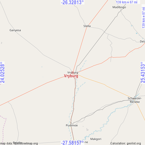
Vryburg GPS coordinates[2]
26° 57' 23.724" South, 24° 43' 42.24" East
| Map corner | latitude | longitude |
|---|---|---|
| Upper-left | -26.32813°, | 24.02528° |
| Center: | -26.95659°, | 24.7284° |
| Lower-right: | -27.58157°, | 25.43153° |
| Map W x H: | 139.4×139.4 km | = 86.6×86.6mi |
| max Lat: | -22.34881° ⇑31.3% North |
| Vryburg: | -26.95659° |
| min Lat: | ⇓68.7% South -34.66739° |
| min Long | Vryburg | max Long |
| 16.8697° | 24.7284° | 32.26762° |
| W 23.9%⇐ | ⇒76.1% E |
Elevation
Elevation of Vryburg is 1202 m = 3944 ft, and this is 232.4 m = 762 ft above average elevation for this country.
| Max E: |
1873 m = 6145 ft | 44% |
| Vryburg | 1202 m 3944 ft | |
| Avg. | 969.6 m = 3181 ft | |
Min E: |
7 m = 23 ft | 56% |
See also: Vryburg elevation on elevation.city.
Geographical zone
Vryburg is located in South temperate zone (between Tropic of Capricorn and the Antarctic Circle). Distance of this Southern Tropic circle is 391.4 km =243.2 mi to North.| Distance of | km | miles | from Vryburg |
|---|---|---|---|
| Equator | 2997.3 | 1862.4 | to North |
| Tropic Capricorn | 391.4 | 243.2 | to North |
| Antarctic Circle | 4403.9 | 2736.5 | to South |
| South Pole | 7009.8 | 4355.7 | to South |


Nearby cities:
15 places around Vryburg: (largest is in red/bold)
• Bloemhof
115.9 km =72 mi,  131°
131°
• Christiana
114.7 km =71.3 mi,  158°
158°
• Delareyville
78.5 km =48.8 mi,  67°
67°
• Ganyesa
67.9 km =42.2 mi,  306°
306°
• Hartswater
88.4 km =54.9 mi,  175°
175°
• Hoopstad
151.8 km =94.3 mi, 129°
• Jan Kempdorp
107.9 km =67 mi,  174°
174°
• Kuruman
139.5 km =86.7 mi,  246°
246°
• Mahikeng
151.8 km =94.3 mi,  36°
36°
• Mmabatho
152.5 km =94.8 mi, 36°
• Pampierstad
92 km =57.2 mi, 182°
• Schweizer-Reneke
64.9 km =40.3 mi,  113°
113°
• Taung
64.1 km =39.8 mi, 174°
• Warrenton
129.2 km =80.3 mi, 174°
• Wolmaransstad
127.1 km =79 mi,  102°
102°
Sources, notices
• [Note1] Compared only with cities in South Africa existing in our database
• [Src1] Map data: © OpenStreetMap contributors (CC-BY-SA)
• [Src2] Other city data from geonames.org with taken over terms of usage.
• [Src3] Geographical zone / Annual Mean Temperature by Robert A. Rohde @ Wikipedia
