Mmabatho geodata
Mmabatho (North-West) is a section of populated place; located in South Africa in Africa/Johannesburg (GMT+2) time zone. With population of 76,754 people, there are 68 cities with bigger population in this country. Compared to other cities in South Africa, 85.8% of cities are located further ↓South; 69.9% of cities are located further →East and 62.5% of cities have lower elevation than Mmabatho. Note1
Administrative division(s):
- Level 1: North-West
- Level 2: Ngaka Modiri Molema District Municipality
- Level 3: Mafikeng


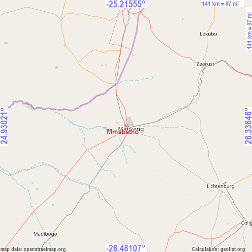
Mmabatho GPS coordinates[2]
25° 51' 0" South, 25° 37' 59.988" East
| Map corner | latitude | longitude |
|---|---|---|
| Upper-left | -25.21555°, | 24.93021° |
| Center: | -25.85°, | 25.63333° |
| Lower-right: | -26.48107°, | 26.33646° |
| Map W x H: | 140.7×140.7 km | = 87.4×87.4mi |
| max Lat: | -22.34881° ⇑14.2% North |
| Mmabatho: | -25.85° |
| min Lat: | ⇓85.8% South -34.66739° |
| min Long | Mmabatho | max Long |
| 16.8697° | 25.63333° | 32.26762° |
| W 30.1%⇐ | ⇒69.9% E |
Elevation
Elevation of Mmabatho is 1282 m = 4206 ft, and this is 312.4 m = 1025 ft above average elevation for this country.
| Max E: |
1873 m = 6145 ft | 37.5% |
| Mmabatho | 1282 m 4206 ft | |
| Avg. | 969.6 m = 3181 ft | |
Min E: |
7 m = 23 ft | 62.5% |
See also: Mmabatho elevation on elevation.city.
Geographical zone
Mmabatho is located in South temperate zone (between Tropic of Capricorn and the Antarctic Circle). Distance of this Southern Tropic circle is 268.3 km =166.7 mi to North.| Distance of | km | miles | from Mmabatho |
|---|---|---|---|
| Equator | 2874.3 | 1786 | to North |
| Tropic Capricorn | 268.3 | 166.7 | to North |
| Antarctic Circle | 4526.9 | 2812.9 | to South |
| South Pole | 7132.8 | 4432.1 | to South |


Nearby cities:
15 places around Mmabatho: (largest is in red/bold)
• Delareyville
94.6 km =58.8 mi,  190°
190°
• Ganyesa
167.4 km =104 mi,  240°
240°
• Klerksdorp
151.7 km =94.3 mi,  137°
137°
• Koster
126.5 km =78.6 mi,  90°
90°
• Lichtenburg
62.4 km =38.8 mi,  122°
122°
• Mahikeng
2 km =1.2 mi,  147°
147°
• Mogwase
171 km =106.3 mi,  68°
68°
• Orkney
162.8 km =101.2 mi, 140°
• Rustenburg
162.4 km =100.9 mi,  82°
82°
• Schweizer-Reneke
151.9 km =94.4 mi, 191°
• Stilfontein
158.2 km =98.3 mi,  134°
134°
• Ventersdorp
129.5 km =80.5 mi,  113°
113°
• Vryburg
152.5 km =94.8 mi,  216°
216°
• Wolmaransstad
153.8 km =95.6 mi,  166°
166°
• Zeerust
56.3 km =35 mi,  51°
51°
Sources, notices
• [Note1] Compared only with cities in South Africa existing in our database
• [Src1] Map data: © OpenStreetMap contributors (CC-BY-SA)
• [Src2] Other city data from geonames.org with taken over terms of usage.
• [Src3] Geographical zone / Annual Mean Temperature by Robert A. Rohde @ Wikipedia
