Taung geodata
Taung (North-West) is a seat of a third-order administrative division; located in South Africa in Africa/Johannesburg (GMT+2) time zone. In our database, there are 257 cities with bigger population. Compared to other cities in South Africa, 63.1% of cities are located further ↓South; 75.2% of cities are located further →East and 50.4% of cities have lower elevation than Taung. Note1
Administrative division(s):
- Level 1: North-West
- Level 2: Dr Ruth Segomotsi Mompati District Municipality
- Level 3: Greater Taung


Taung GPS coordinates[2]
27° 31' 52.068" South, 24° 47' 11.724" East
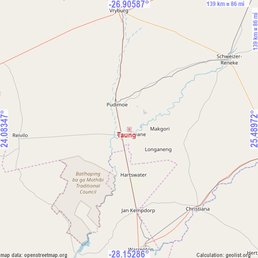
| Map corner | latitude | longitude |
|---|---|---|
| Upper-left | -26.90587°, | 24.08347° |
| Center: | -27.53113°, | 24.78659° |
| Lower-right: | -28.15286°, | 25.48972° |
| Map W x H: | 138.7×138.7 km | = 86.2×86.2mi |
| max Lat: | -22.34881° ⇑36.9% North |
| Taung: | -27.53113° |
| min Lat: | ⇓63.1% South -34.66739° |
| min Long | Taung | max Long |
| 16.8697° | 24.78659° | 32.26762° |
| W 24.8%⇐ | ⇒75.2% E |
Elevation
Elevation of Taung is 1118 m = 3668 ft, and this is 148.4 m = 487 ft above average elevation for this country.
| Max E: |
1873 m = 6145 ft | 49.6% |
| Taung | 1118 m 3668 ft | |
| Avg. | 969.6 m = 3181 ft | |
Min E: |
7 m = 23 ft | 50.4% |
See also: South Africa elevation on elevation.city.
Geographical zone
Taung is located in South temperate zone (between Tropic of Capricorn and the Antarctic Circle). Distance of this Southern Tropic circle is 455.3 km =282.9 mi to North.| Distance of | km | miles | from Taung |
|---|---|---|---|
| Equator | 3061.2 | 1902.1 | to North |
| Tropic Capricorn | 455.3 | 282.9 | to North |
| Antarctic Circle | 4340 | 2696.8 | to South |
| South Pole | 6945.9 | 4316 | to South |


Nearby cities:
15 places around Taung: (largest is in red/bold)
• Barkly West
114.7 km =71.3 mi,  193°
193°
• Bloemhof
81.9 km =50.9 mi,  99°
99°
• Boshof
120.6 km =74.9 mi,  158°
158°
• Christiana
56.3 km =35 mi,  139°
139°
• Delareyville
115.1 km =71.5 mi,  35°
35°
• Ganyesa
120.3 km =74.8 mi,  329°
329°
• Hartswater
24.3 km =15.1 mi,  177°
177°
• Hoopstad
115.4 km =71.7 mi,  106°
106°
• Jan Kempdorp
43.7 km =27.2 mi,  174°
174°
• Kimberley
133.6 km =83 mi, 181°
• Pampierstad
29.7 km =18.5 mi,  199°
199°
• Schweizer-Reneke
65.7 km =40.8 mi,  54°
54°
• Vryburg
64.1 km =39.8 mi,  354°
354°
• Warrenton
65.1 km =40.5 mi, 174°
• Wolmaransstad
123.8 km =76.9 mi,  72°
72°
Sources, notices
• [Note1] Compared only with cities in South Africa existing in our database
• [Src1] Map data: © OpenStreetMap contributors (CC-BY-SA)
• [Src2] Other city data from geonames.org with taken over terms of usage.
• [Src3] Geographical zone / Annual Mean Temperature by Robert A. Rohde @ Wikipedia
