Kuruman geodata
Kuruman (Northern Cape) is a seat of a second-order administrative division; located in South Africa in Africa/Johannesburg (GMT+2) time zone. With population of 9,093 people, there are 223 cities with bigger population in this country. Compared to other cities in South Africa, 63.4% of cities are located further ↓South; 80.5% of cities are located further →East and 66.7% of cities have lower elevation than Kuruman. Note1
Administrative division(s):
- Level 1: Northern Cape
- Level 2: John Taolo Gaetsewe District Municipality
- Level 3: Ga-Segonyana


Kuruman GPS coordinates[2]
27° 27' 8.64" South, 23° 25' 56.856" East
| Map corner | latitude | longitude |
|---|---|---|
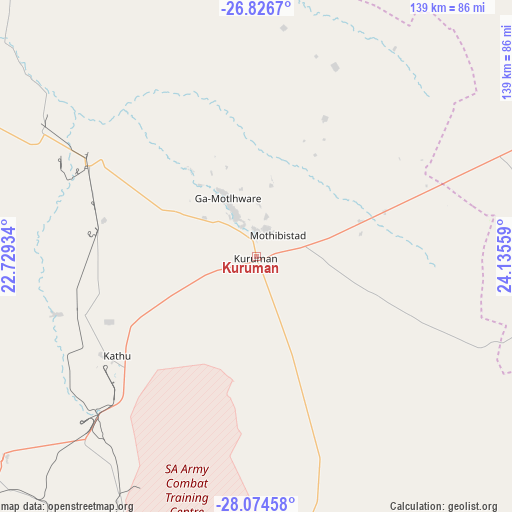
| Upper-left | -26.8267°, | 22.72934° |
| Center: | -27.4524°, | 23.43246° |
| Lower-right: | -28.07458°, | 24.13559° |
| Map W x H: | 138.8×138.8 km | = 86.2×86.2mi |
| max Lat: | -22.34881° ⇑36.6% North |
| Kuruman: | -27.4524° |
| min Lat: | ⇓63.4% South -34.66739° |
| min Long | Kuruman | max Long |
| 16.8697° | 23.43246° | 32.26762° |
| W 19.5%⇐ | ⇒80.5% E |
Elevation
Elevation of Kuruman is 1323 m = 4341 ft, and this is 353.4 m = 1159 ft above average elevation for this country.
| Max E: |
1873 m = 6145 ft | 33.3% |
| Kuruman | 1323 m 4341 ft | |
| Avg. | 969.6 m = 3181 ft | |
Min E: |
7 m = 23 ft | 66.7% |
See also: South Africa elevation on elevation.city.
Geographical zone
Kuruman is located in South temperate zone (between Tropic of Capricorn and the Antarctic Circle). Distance of this Southern Tropic circle is 446.5 km =277.4 mi to North.| Distance of | km | miles | from Kuruman |
|---|---|---|---|
| Equator | 3052.4 | 1896.7 | to North |
| Tropic Capricorn | 446.5 | 277.4 | to North |
| Antarctic Circle | 4348.8 | 2702.2 | to South |
| South Pole | 6954.6 | 4321.4 | to South |


Nearby cities:
15 places around Kuruman: (largest is in red/bold)
• Barkly West
161 km =100 mi,  138°
138°
• Christiana
177.8 km =110.5 mi,  106°
106°
• Daniëlskuil
82.5 km =51.3 mi,  172°
172°
• Douglas
181.3 km =112.7 mi, 169°
• Ganyesa
120.4 km =74.8 mi,  37°
37°
• Hartswater
138.5 km =86.1 mi,  103°
103°
• Jan Kempdorp
147.2 km =91.5 mi, 110°
• Kathu
46.5 km =28.9 mi,  234°
234°
• Kimberley
193 km =119.9 mi, 137°
• Pampierstad
129 km =80.2 mi, 106°
• Postmasburg
104.4 km =64.9 mi,  200°
200°
• Schweizer-Reneke
189.7 km =117.9 mi,  81°
81°
• Taung
133.8 km =83.1 mi,  93°
93°
• Vryburg
139.5 km =86.7 mi,  66°
66°
• Warrenton
157.4 km =97.8 mi,  117°
117°
Sources, notices
• [Note1] Compared only with cities in South Africa existing in our database
• [Src1] Map data: © OpenStreetMap contributors (CC-BY-SA)
• [Src2] Other city data from geonames.org with taken over terms of usage.
• [Src3] Geographical zone / Annual Mean Temperature by Robert A. Rohde @ Wikipedia
