Breyten geodata
Breyten (Mpumalanga) is a populated place; located in South Africa in Africa/Johannesburg (GMT+2) time zone. With population of 12,550 people, there are 183 cities with bigger population in this country. Compared to other cities in South Africa, 76.1% of cities are located further ↓South; 79.9% of cities are located further ←West and 99.1% of cities have lower elevation than Breyten. Note1
Administrative division(s):
- Level 1: Mpumalanga
- Level 2: Gert Sibande District Municipality
- Level 3: Msukaligwa


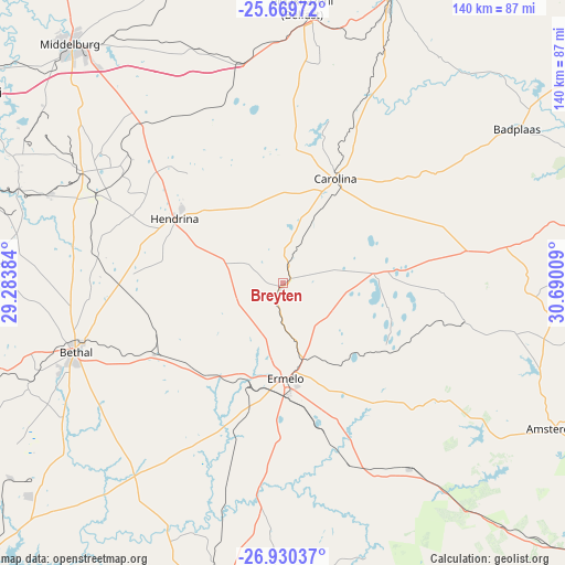
Breyten GPS coordinates[2]
26° 18' 6.336" South, 29° 59' 13.056" East
| Map corner | latitude | longitude |
|---|---|---|
| Upper-left | -25.66972°, | 29.28384° |
| Center: | -26.30176°, | 29.98696° |
| Lower-right: | -26.93037°, | 30.69009° |
| Map W x H: | 140.2×140.2 km | = 87.1×87.1mi |
| max Lat: | -22.34881° ⇑23.9% North |
| Breyten: | -26.30176° |
| min Lat: | ⇓76.1% South -34.66739° |
| min Long | Breyten | max Long |
| 16.8697° | 29.98696° | 32.26762° |
| W 79.9%⇐ | ⇒20.1% E |
Elevation
Elevation of Breyten is 1753 m = 5751 ft, and this is 783.4 m = 2570 ft above average elevation for this country.
| Max E: |
1873 m = 6145 ft | 0.90000000000001% |
| Breyten | 1753 m 5751 ft | |
| Avg. | 969.6 m = 3181 ft | |
Min E: |
7 m = 23 ft | 99.1% |
See also: South Africa elevation on elevation.city.
Geographical zone
Breyten is located in South temperate zone (between Tropic of Capricorn and the Antarctic Circle). Distance of this Southern Tropic circle is 318.6 km =198 mi to North.| Distance of | km | miles | from Breyten |
|---|---|---|---|
| Equator | 2924.5 | 1817.2 | to North |
| Tropic Capricorn | 318.6 | 198 | to North |
| Antarctic Circle | 4476.7 | 2781.7 | to South |
| South Pole | 7082.6 | 4400.9 | to South |


Nearby cities:
15 places around Breyten: (largest is in red/bold)
• Barberton
120.8 km =75.1 mi,  61°
61°
• Belfast
68.2 km =42.4 mi,  4°
4°
• Bethal
54.8 km =34.1 mi,  251°
251°
• Carolina
28.8 km =17.9 mi,  26°
26°
• Driefontein
91.9 km =57.1 mi,  149°
149°
• Ermelo
25.8 km =16 mi,  180°
180°
• Hendrina
31.4 km =19.5 mi,  300°
300°
• Kriel
76 km =47.2 mi,  272°
272°
• Middelburg
78.4 km =48.7 mi,  318°
318°
• Piet Retief
113.5 km =70.5 mi,  133°
133°
• Secunda
86.2 km =53.6 mi, 251°
• Standerton
102.1 km =63.4 mi,  226°
226°
• Volksrust
118.7 km =73.8 mi,  185°
185°
• Witbank
89.2 km =55.4 mi, 302°
• eMbalenhle
95.2 km =59.2 mi, 254°
Sources, notices
• [Note1] Compared only with cities in South Africa existing in our database
• [Src1] Map data: © OpenStreetMap contributors (CC-BY-SA)
• [Src2] Other city data from geonames.org with taken over terms of usage.
• [Src3] Geographical zone / Annual Mean Temperature by Robert A. Rohde @ Wikipedia
