Ermelo geodata
Ermelo (Mpumalanga) is a seat of a third-order administrative division; located in South Africa in Africa/Johannesburg (GMT+2) time zone. With population of 41,124 people, there are 104 cities with bigger population in this country. Compared to other cities in South Africa, 73.2% of cities are located further ↓South; 79.6% of cities are located further ←West and 97.9% of cities have lower elevation than Ermelo. Note1
Administrative division(s):
- Level 1: Mpumalanga
- Level 2: Gert Sibande District Municipality
- Level 3: Msukaligwa


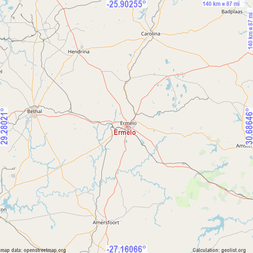
Ermelo GPS coordinates[2]
26° 31' 59.988" South, 29° 58' 59.988" East
| Map corner | latitude | longitude |
|---|---|---|
| Upper-left | -25.90255°, | 29.28021° |
| Center: | -26.53333°, | 29.98333° |
| Lower-right: | -27.16066°, | 30.68646° |
| Map W x H: | 139.9×139.9 km | = 86.9×86.9mi |
| max Lat: | -22.34881° ⇑26.8% North |
| Ermelo: | -26.53333° |
| min Lat: | ⇓73.2% South -34.66739° |
| min Long | Ermelo | max Long |
| 16.8697° | 29.98333° | 32.26762° |
| W 79.6%⇐ | ⇒20.4% E |
Elevation
Elevation of Ermelo is 1700 m = 5577 ft, and this is 730.4 m = 2396 ft above average elevation for this country.
| Max E: |
1873 m = 6145 ft | 2.1% |
| Ermelo | 1700 m 5577 ft | |
| Avg. | 969.6 m = 3181 ft | |
Min E: |
7 m = 23 ft | 97.9% |
See also: Ermelo elevation on elevation.city.
Geographical zone
Ermelo is located in South temperate zone (between Tropic of Capricorn and the Antarctic Circle). Distance of this Southern Tropic circle is 344.3 km =213.9 mi to North.| Distance of | km | miles | from Ermelo |
|---|---|---|---|
| Equator | 2950.2 | 1833.2 | to North |
| Tropic Capricorn | 344.3 | 213.9 | to North |
| Antarctic Circle | 4450.9 | 2765.7 | to South |
| South Pole | 7056.8 | 4384.9 | to South |


Nearby cities:
15 places around Ermelo: (largest is in red/bold)
• Belfast
93.9 km =58.3 mi,  3°
3°
• Bethal
52.2 km =32.4 mi,  279°
279°
• Breyten
25.8 km =16 mi, 0°
• Carolina
53.2 km =33.1 mi,  14°
14°
• Driefontein
71 km =44.1 mi,  139°
139°
• Hendrina
49.5 km =30.8 mi,  327°
327°
• Kriel
80.8 km =50.2 mi,  290°
290°
• Middelburg
98.9 km =61.5 mi, 328°
• Piet Retief
97.8 km =60.8 mi,  122°
122°
• Secunda
81.3 km =50.5 mi,  268°
268°
• Standerton
86.1 km =53.5 mi,  238°
238°
• Volksrust
93.1 km =57.8 mi,  186°
186°
• Vrede
128.1 km =79.6 mi,  219°
219°
• Witbank
105 km =65.2 mi,  314°
314°
• eMbalenhle
91.2 km =56.7 mi, 270°
Sources, notices
• [Note1] Compared only with cities in South Africa existing in our database
• [Src1] Map data: © OpenStreetMap contributors (CC-BY-SA)
• [Src2] Other city data from geonames.org with taken over terms of usage.
• [Src3] Geographical zone / Annual Mean Temperature by Robert A. Rohde @ Wikipedia
