Nelspruit geodata
Nelspruit (Mpumalanga) is a seat of a first-order administrative division; located in South Africa in Africa/Johannesburg (GMT+2) time zone. With population of 110,159 people, there are 48 cities with bigger population in this country. Compared to other cities in South Africa, 89.7% of cities are located further ↓South; 92% of cities are located further ←West and 69.9% of cities have higher elevation than Nelspruit. Note1


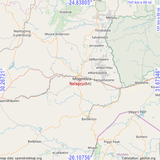
Nelspruit GPS coordinates[2]
25° 28' 28.128" South, 30° 58' 13.188" East
| Map corner | latitude | longitude |
|---|---|---|
| Upper-left | -24.83805°, | 30.26721° |
| Center: | -25.47448°, | 30.97033° |
| Lower-right: | -26.10756°, | 31.67346° |
| Map W x H: | 141.2×141.2 km | = 87.7×87.7mi |
| max Lat: | -22.34881° ⇑10.3% North |
| Nelspruit: | -25.47448° |
| min Lat: | ⇓89.7% South -34.66739° |
| min Long | Nelspruit | max Long |
| 16.8697° | 30.97033° | 32.26762° |
| W 92%⇐ | ⇒8% E |
Elevation
Elevation of Nelspruit is 676 m = 2218 ft, and this is 293.6 m = 963 ft below average elevation for this country.
| Max E: |
1873 m = 6145 ft | 69.9% |
| Avg. | 969.6 m = 3181 ft | |
| Nelspruit | 676 m = 2218 ft | |
Min E: |
7 m = 23 ft | 30.1% |
See also: Nelspruit elevation on elevation.city.
Geographical zone
Nelspruit is located in South temperate zone (between Tropic of Capricorn and the Antarctic Circle). Distance of this Southern Tropic circle is 226.6 km =140.8 mi to North.| Distance of | km | miles | from Nelspruit |
|---|---|---|---|
| Equator | 2832.5 | 1760 | to North |
| Tropic Capricorn | 226.6 | 140.8 | to North |
| Antarctic Circle | 4568.7 | 2838.9 | to South |
| South Pole | 7174.6 | 4458.1 | to South |


Nearby cities:
15 places around Nelspruit: (largest is in red/bold)
• Barberton
35.9 km =22.3 mi,  166°
166°
• Belfast
96.8 km =60.1 mi,  255°
255°
• Breyten
134.7 km =83.7 mi,  226°
226°
• Burgersfort
109.8 km =68.2 mi,  323°
323°
• Carolina
108.2 km =67.2 mi, 232°
• Ermelo
153.6 km =95.4 mi,  219°
219°
• Groblersdal
162 km =100.7 mi,  282°
282°
• Hendrina
146.9 km =91.3 mi,  238°
238°
• Hoedspruit
124.9 km =77.6 mi,  359°
359°
• Jane Furse
136.3 km =84.7 mi,  305°
305°
• Komatipoort
98.9 km =61.5 mi,  87°
87°
• Lydenburg
67.6 km =42 mi, 308°
• Middelburg
154.6 km =96.1 mi, 257°
• Thulamahashi
86.5 km =53.7 mi,  15°
15°
• White River
16.4 km =10.2 mi,  14°
14°
Sources, notices
• [Note1] Compared only with cities in South Africa existing in our database
• [Src1] Map data: © OpenStreetMap contributors (CC-BY-SA)
• [Src2] Other city data from geonames.org with taken over terms of usage.
• [Src3] Geographical zone / Annual Mean Temperature by Robert A. Rohde @ Wikipedia
