Thulamahashi geodata
Thulamahashi (Limpopo) is a populated place; located in South Africa in Africa/Johannesburg (GMT+2) time zone. With population of 11,655 people, there are 200 cities with bigger population in this country. Compared to other cities in South Africa, 93.5% of cities are located further ↓South; 94.4% of cities are located further ←West and 76.1% of cities have higher elevation than Thulamahashi. Note1


Thulamahashi GPS coordinates[2]
24° 43' 28.524" South, 31° 11' 57.804" East
| Map corner | latitude | longitude |
|---|---|---|
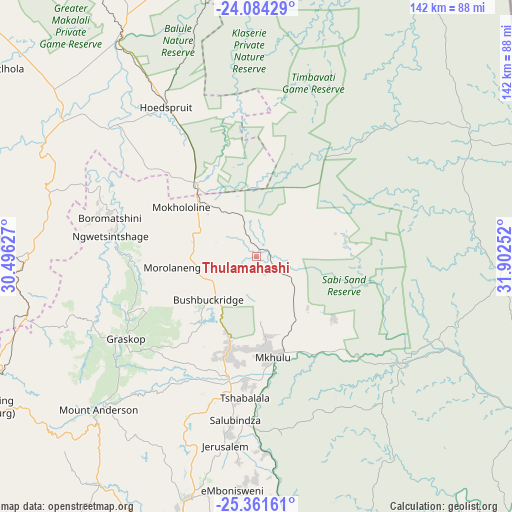
| Upper-left | -24.08429°, | 30.49627° |
| Center: | -24.72459°, | 31.19939° |
| Lower-right: | -25.36161°, | 31.90252° |
| Map W x H: | 142×142 km | = 88.2×88.2mi |
| max Lat: | -22.34881° ⇑6.5% North |
| Thulamahashi: | -24.72459° |
| min Lat: | ⇓93.5% South -34.66739° |
| min Long | Thulamahashi | max Long |
| 16.8697° | 31.19939° | 32.26762° |
| W 94.4%⇐ | ⇒5.6% E |
Elevation
Elevation of Thulamahashi is 488 m = 1601 ft, and this is 481.6 m = 1580 ft below average elevation for this country.
| Max E: |
1873 m = 6145 ft | 76.1% |
| Avg. | 969.6 m = 3181 ft | |
| Thulamahashi | 488 m = 1601 ft | |
Min E: |
7 m = 23 ft | 23.9% |
See also: South Africa elevation on elevation.city.
Geographical zone
Thulamahashi is located in South temperate zone (between Tropic of Capricorn and the Antarctic Circle). Distance of this Southern Tropic circle is 143.2 km =89 mi to North.| Distance of | km | miles | from Thulamahashi |
|---|---|---|---|
| Equator | 2749.1 | 1708.2 | to North |
| Tropic Capricorn | 143.2 | 89 | to North |
| Antarctic Circle | 4652.1 | 2890.7 | to South |
| South Pole | 7257.9 | 4509.8 | to South |


Nearby cities:
15 places around Thulamahashi: (largest is in red/bold)
• Apel
150.6 km =93.6 mi,  283°
283°
• Barberton
119.2 km =74.1 mi,  187°
187°
• Belfast
158.9 km =98.7 mi,  227°
227°
• Burgersfort
88.1 km =54.7 mi,  273°
273°
• Duiwelskloof
157.1 km =97.6 mi,  316°
316°
• Ga-Kgapane
155.7 km =96.7 mi, 320°
• Hoedspruit
48.4 km =30.1 mi,  329°
329°
• Jane Furse
134.3 km =83.5 mi, 268°
• Komatipoort
109.5 km =68 mi,  136°
136°
• Lydenburg
86.7 km =53.9 mi,  241°
241°
• Nelspruit
86.5 km =53.7 mi,  195°
195°
• Nkowakowa
131.2 km =81.5 mi, 315°
• Phalaborwa
87.1 km =54.1 mi,  356°
356°
• Tzaneen
144.4 km =89.7 mi,  313°
313°
• White River
70.1 km =43.6 mi, 195°
Sources, notices
• [Note1] Compared only with cities in South Africa existing in our database
• [Src1] Map data: © OpenStreetMap contributors (CC-BY-SA)
• [Src2] Other city data from geonames.org with taken over terms of usage.
• [Src3] Geographical zone / Annual Mean Temperature by Robert A. Rohde @ Wikipedia
