Barberton geodata
Barberton (Mpumalanga) is a seat of a third-order administrative division; located in South Africa in Africa/Johannesburg (GMT+2) time zone. With population of 67,927 people, there are 77 cities with bigger population in this country. Compared to other cities in South Africa, 86.4% of cities are located further ↓South; 93.2% of cities are located further ←West and 63.4% of cities have higher elevation than Barberton. Note1


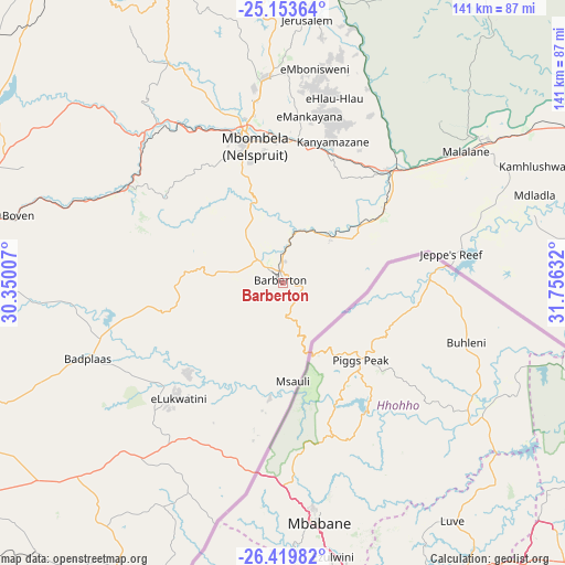
Barberton GPS coordinates[2]
25° 47' 18.312" South, 31° 3' 11.484" East
| Map corner | latitude | longitude |
|---|---|---|
| Upper-left | -25.15364°, | 30.35007° |
| Center: | -25.78842°, | 31.05319° |
| Lower-right: | -26.41982°, | 31.75632° |
| Map W x H: | 140.8×140.8 km | = 87.5×87.5mi |
| max Lat: | -22.34881° ⇑13.6% North |
| Barberton: | -25.78842° |
| min Lat: | ⇓86.4% South -34.66739° |
| min Long | Barberton | max Long |
| 16.8697° | 31.05319° | 32.26762° |
| W 93.2%⇐ | ⇒6.8% E |
Elevation
Elevation of Barberton is 853 m = 2799 ft, and this is 116.6 m = 383 ft below average elevation for this country.
| Max E: |
1873 m = 6145 ft | 63.4% |
| Avg. | 969.6 m = 3181 ft | |
| Barberton | 853 m = 2799 ft | |
Min E: |
7 m = 23 ft | 36.6% |
See also: Barberton elevation on elevation.city.
Geographical zone
Barberton is located in South temperate zone (between Tropic of Capricorn and the Antarctic Circle). Distance of this Southern Tropic circle is 261.5 km =162.5 mi to North.| Distance of | km | miles | from Barberton |
|---|---|---|---|
| Equator | 2867.4 | 1781.7 | to North |
| Tropic Capricorn | 261.5 | 162.5 | to North |
| Antarctic Circle | 4533.8 | 2817.2 | to South |
| South Pole | 7139.7 | 4436.4 | to South |


Nearby cities:
15 places around Barberton: (largest is in red/bold)
• Belfast
102.6 km =63.8 mi,  276°
276°
• Breyten
120.8 km =75.1 mi,  241°
241°
• Burgersfort
143.6 km =89.2 mi,  329°
329°
• Carolina
98.9 km =61.5 mi,  251°
251°
• Driefontein
149.3 km =92.8 mi,  203°
203°
• Ermelo
135.1 km =83.9 mi,  232°
232°
• Hendrina
139.9 km =86.9 mi, 252°
• Hoedspruit
160.1 km =99.5 mi,  356°
356°
• Komatipoort
98.6 km =61.3 mi,  66°
66°
• Lydenburg
98.3 km =61.1 mi,  321°
321°
• Middelburg
159 km =98.8 mi,  270°
270°
• Nelspruit
35.9 km =22.3 mi,  346°
346°
• Piet Retief
137.6 km =85.5 mi,  190°
190°
• Thulamahashi
119.2 km =74.1 mi,  7°
7°
• White River
50.9 km =31.6 mi, 355°
Sources, notices
• [Note1] Compared only with cities in South Africa existing in our database
• [Src1] Map data: © OpenStreetMap contributors (CC-BY-SA)
• [Src2] Other city data from geonames.org with taken over terms of usage.
• [Src3] Geographical zone / Annual Mean Temperature by Robert A. Rohde @ Wikipedia
