Glencoe geodata
Glencoe (KwaZulu-Natal) is a populated place; located in South Africa in Africa/Johannesburg (GMT+2) time zone. With population of 13,547 people, there are 178 cities with bigger population in this country. Compared to other cities in South Africa, 54.6% of cities are located further ↓South; 82.6% of cities are located further ←West and 63.4% of cities have lower elevation than Glencoe. Note1
Administrative division(s):
- Level 1: KwaZulu-Natal
- Level 2: uMzinyathi District Municipality
- Level 3: Endumeni


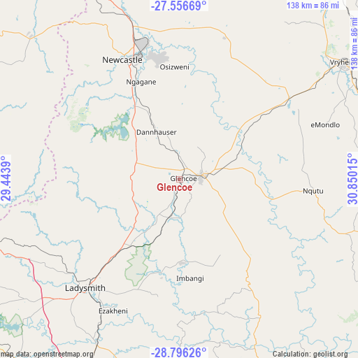
Glencoe GPS coordinates[2]
28° 10' 41.772" South, 30° 8' 49.272" East
| Map corner | latitude | longitude |
|---|---|---|
| Upper-left | -27.55669°, | 29.4439° |
| Center: | -28.17827°, | 30.14702° |
| Lower-right: | -28.79626°, | 30.85015° |
| Map W x H: | 137.8×137.8 km | = 85.6×85.6mi |
| max Lat: | -22.34881° ⇑45.4% North |
| Glencoe: | -28.17827° |
| min Lat: | ⇓54.6% South -34.66739° |
| min Long | Glencoe | max Long |
| 16.8697° | 30.14702° | 32.26762° |
| W 82.6%⇐ | ⇒17.4% E |
Elevation
Elevation of Glencoe is 1293 m = 4242 ft, and this is 323.4 m = 1061 ft above average elevation for this country.
| Max E: |
1873 m = 6145 ft | 36.6% |
| Glencoe | 1293 m 4242 ft | |
| Avg. | 969.6 m = 3181 ft | |
Min E: |
7 m = 23 ft | 63.4% |
See also: South Africa elevation on elevation.city.
Geographical zone
Glencoe is located in South temperate zone (between Tropic of Capricorn and the Antarctic Circle). Distance of this Southern Tropic circle is 527.2 km =327.6 mi to North.| Distance of | km | miles | from Glencoe |
|---|---|---|---|
| Equator | 3133.1 | 1946.8 | to North |
| Tropic Capricorn | 527.2 | 327.6 | to North |
| Antarctic Circle | 4268 | 2652 | to South |
| South Pole | 6873.9 | 4271.2 | to South |


Nearby cities:
15 places around Glencoe: (largest is in red/bold)
• Bergville
99.1 km =61.6 mi,  231°
231°
• Dannhauser
20.2 km =12.6 mi,  333°
333°
• Dundee
8.6 km =5.3 mi,  81°
81°
• Ekuvukeni
32.2 km =20 mi,  178°
178°
• Estcourt
96.7 km =60.1 mi,  196°
196°
• Harrismith
100.2 km =62.3 mi,  263°
263°
• Ladysmith
55.6 km =34.5 mi,  220°
220°
• Mondlo
60 km =37.3 mi,  68°
68°
• Newcastle
51.3 km =31.9 mi,  335°
335°
• Nkandla
104.6 km =65 mi,  118°
118°
• Paulpietersburg
106.6 km =66.2 mi,  38°
38°
• Tugela Ferry
69.8 km =43.4 mi,  154°
154°
• Utrecht
60.3 km =37.5 mi,  16°
16°
• Volksrust
94.1 km =58.5 mi, 343°
• Vryheid
77.9 km =48.4 mi,  54°
54°
Sources, notices
• [Note1] Compared only with cities in South Africa existing in our database
• [Src1] Map data: © OpenStreetMap contributors (CC-BY-SA)
• [Src2] Other city data from geonames.org with taken over terms of usage.
• [Src3] Geographical zone / Annual Mean Temperature by Robert A. Rohde @ Wikipedia
