Dundee geodata
Dundee (KwaZulu-Natal) is a seat of a second-order administrative division; located in South Africa in Africa/Johannesburg (GMT+2) time zone. With population of 84,413 people, there are 62 cities with bigger population in this country. Compared to other cities in South Africa, 54.9% of cities are located further ↓South; 84.4% of cities are located further ←West and 61.1% of cities have lower elevation than Dundee. Note1
Administrative division(s):
- Level 1: KwaZulu-Natal
- Level 2: uMzinyathi District Municipality
- Level 3: Endumeni


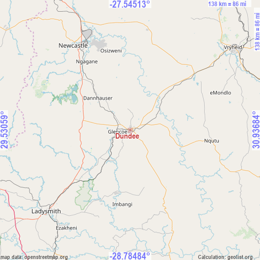
Dundee GPS coordinates[2]
28° 10' 0.408" South, 30° 14' 1.356" East
| Map corner | latitude | longitude |
|---|---|---|
| Upper-left | -27.54513°, | 29.53059° |
| Center: | -28.16678°, | 30.23371° |
| Lower-right: | -28.78484°, | 30.93684° |
| Map W x H: | 137.8×137.8 km | = 85.6×85.6mi |
| max Lat: | -22.34881° ⇑45.1% North |
| Dundee: | -28.16678° |
| min Lat: | ⇓54.9% South -34.66739° |
| min Long | Dundee | max Long |
| 16.8697° | 30.23371° | 32.26762° |
| W 84.4%⇐ | ⇒15.6% E |
Elevation
Elevation of Dundee is 1260 m = 4134 ft, and this is 290.4 m = 953 ft above average elevation for this country.
| Max E: |
1873 m = 6145 ft | 38.9% |
| Dundee | 1260 m 4134 ft | |
| Avg. | 969.6 m = 3181 ft | |
Min E: |
7 m = 23 ft | 61.1% |
See also: Dundee elevation on elevation.city.
Geographical zone
Dundee is located in South temperate zone (between Tropic of Capricorn and the Antarctic Circle). Distance of this Southern Tropic circle is 525.9 km =326.8 mi to North.| Distance of | km | miles | from Dundee |
|---|---|---|---|
| Equator | 3131.9 | 1946.1 | to North |
| Tropic Capricorn | 525.9 | 326.8 | to North |
| Antarctic Circle | 4269.3 | 2652.8 | to South |
| South Pole | 6875.2 | 4272 | to South |


Nearby cities:
15 places around Dundee: (largest is in red/bold)
• Bergville
106.6 km =66.2 mi,  233°
233°
• Dannhauser
24.2 km =15 mi,  314°
314°
• Ekuvukeni
34.3 km =21.3 mi,  192°
192°
• Estcourt
100.7 km =62.6 mi,  200°
200°
• Glencoe
8.6 km =5.3 mi,  261°
261°
• Greytown
105.8 km =65.7 mi,  160°
160°
• Ladysmith
62.3 km =38.7 mi, 225°
• Mondlo
51.7 km =32.1 mi,  66°
66°
• Newcastle
54.3 km =33.7 mi,  326°
326°
• Nkandla
97.8 km =60.8 mi,  121°
121°
• Paulpietersburg
100.5 km =62.4 mi,  34°
34°
• Tugela Ferry
67.9 km =42.2 mi, 161°
• Utrecht
57.2 km =35.5 mi,  8°
8°
• Volksrust
95.6 km =59.4 mi,  338°
338°
• Vryheid
70.4 km =43.7 mi,  51°
51°
Sources, notices
• [Note1] Compared only with cities in South Africa existing in our database
• [Src1] Map data: © OpenStreetMap contributors (CC-BY-SA)
• [Src2] Other city data from geonames.org with taken over terms of usage.
• [Src3] Geographical zone / Annual Mean Temperature by Robert A. Rohde @ Wikipedia
