Brandvlei geodata
Brandvlei (Northern Cape) is a populated place; located in South Africa in Africa/Johannesburg (GMT+2) time zone. With population of 2,859 people, there are 248 cities with bigger population in this country. Compared to other cities in South Africa, 68.1% of cities are located further ↑North; 88.8% of cities are located further →East and 61.4% of cities have higher elevation than Brandvlei. Note1
Administrative division(s):
- Level 1: Northern Cape
- Level 2: Namakwa District Municipality
- Level 3: Hantam


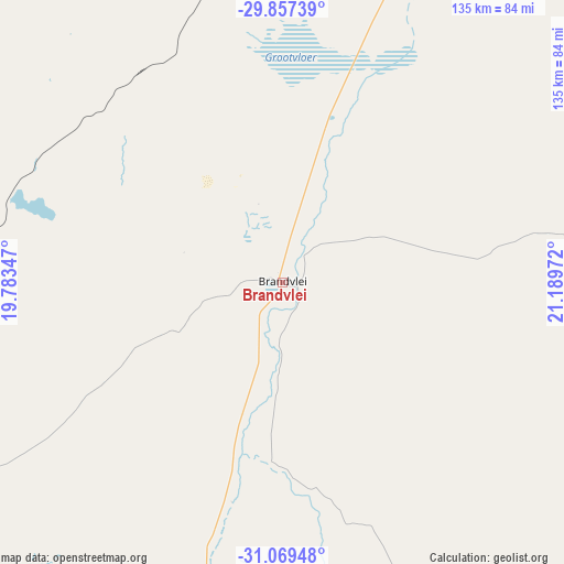
Brandvlei GPS coordinates[2]
30° 27' 55.152" South, 20° 29' 11.724" East
| Map corner | latitude | longitude |
|---|---|---|
| Upper-left | -29.85739°, | 19.78347° |
| Center: | -30.46532°, | 20.48659° |
| Lower-right: | -31.06948°, | 21.18972° |
| Map W x H: | 134.8×134.8 km | = 83.8×83.8mi |
| max Lat: | -22.34881° ⇑68.1% North |
| Brandvlei: | -30.46532° |
| min Lat: | ⇓31.9% South -34.66739° |
| min Long | Brandvlei | max Long |
| 16.8697° | 20.48659° | 32.26762° |
| W 11.2%⇐ | ⇒88.8% E |
Elevation
Elevation of Brandvlei is 921 m = 3022 ft, and this is 48.6 m = 159 ft below average elevation for this country.
| Max E: |
1873 m = 6145 ft | 61.4% |
| Avg. | 969.6 m = 3181 ft | |
| Brandvlei | 921 m = 3022 ft | |
Min E: |
7 m = 23 ft | 38.6% |
See also: South Africa elevation on elevation.city.
Geographical zone
Brandvlei is located in South temperate zone (between Tropic of Capricorn and the Antarctic Circle). Distance of this Southern Tropic circle is 781.5 km =485.6 mi to North.| Distance of | km | miles | from Brandvlei |
|---|---|---|---|
| Equator | 3387.4 | 2104.8 | to North |
| Tropic Capricorn | 781.5 | 485.6 | to North |
| Antarctic Circle | 4013.7 | 2494 | to South |
| South Pole | 6619.6 | 4113.2 | to South |


Nearby cities:
15 places around Brandvlei: (largest is in red/bold)
• Calvinia
130.7 km =81.2 mi,  211°
211°
• Carnarvon
167 km =103.8 mi,  109°
109°
• Clanwilliam
243.6 km =151.4 mi,  218°
218°
• Fraserburg
188.5 km =117.1 mi,  148°
148°
• Garies
239.5 km =148.8 mi,  267°
267°
• Groblershoop
226.7 km =140.9 mi,  39°
39°
• Kakamas
188.5 km =117.1 mi,  3°
3°
• Kenhardt
140.3 km =87.2 mi,  27°
27°
• Pofadder
182.2 km =113.2 mi,  324°
324°
• Prieska
234.5 km =145.7 mi,  67°
67°
• Springbok
265.6 km =165 mi,  289°
289°
• Upington
236.4 km =146.9 mi,  18°
18°
• Van Wyksvlei
129 km =80.2 mi,  84°
84°
• Vredendal
231.6 km =143.9 mi,  234°
234°
• Williston
105.6 km =65.6 mi,  157°
157°
Sources, notices
• [Note1] Compared only with cities in South Africa existing in our database
• [Src1] Map data: © OpenStreetMap contributors (CC-BY-SA)
• [Src2] Other city data from geonames.org with taken over terms of usage.
• [Src3] Geographical zone / Annual Mean Temperature by Robert A. Rohde @ Wikipedia
