Upington geodata
Upington (Northern Cape) is a seat of a second-order administrative division; located in South Africa in Africa/Johannesburg (GMT+2) time zone. With population of 71,373 people, there are 71 cities with bigger population in this country. Compared to other cities in South Africa, 51.6% of cities are located further ↓South; 87% of cities are located further →East and 65.5% of cities have higher elevation than Upington. Note1
Administrative division(s):
- Level 1: Northern Cape
- Level 2: Siyanda District Municipality
- Level 3: //Khara Hais


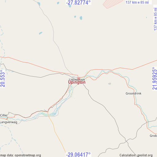
Upington GPS coordinates[2]
28° 26' 51.936" South, 21° 15' 22.032" East
| Map corner | latitude | longitude |
|---|---|---|
| Upper-left | -27.82774°, | 20.553° |
| Center: | -28.44776°, | 21.25612° |
| Lower-right: | -29.06417°, | 21.95925° |
| Map W x H: | 137.5×137.5 km | = 85.4×85.4mi |
| max Lat: | -22.34881° ⇑48.4% North |
| Upington: | -28.44776° |
| min Lat: | ⇓51.6% South -34.66739° |
| min Long | Upington | max Long |
| 16.8697° | 21.25612° | 32.26762° |
| W 13%⇐ | ⇒87% E |
Elevation
Elevation of Upington is 808 m = 2651 ft, and this is 161.6 m = 530 ft below average elevation for this country.
| Max E: |
1873 m = 6145 ft | 65.5% |
| Avg. | 969.6 m = 3181 ft | |
| Upington | 808 m = 2651 ft | |
Min E: |
7 m = 23 ft | 34.5% |
See also: Upington elevation on elevation.city.
Geographical zone
Upington is located in South temperate zone (between Tropic of Capricorn and the Antarctic Circle). Distance of this Southern Tropic circle is 557.2 km =346.2 mi to North.| Distance of | km | miles | from Upington |
|---|---|---|---|
| Equator | 3163.1 | 1965.5 | to North |
| Tropic Capricorn | 557.2 | 346.2 | to North |
| Antarctic Circle | 4238.1 | 2633.4 | to South |
| South Pole | 6844 | 4252.7 | to South |


Nearby cities:
15 places around Upington: (largest is in red/bold)
• Barkly West
319.2 km =198.3 mi,  91°
91°
• Brandvlei
236.4 km =146.9 mi,  198°
198°
• Carnarvon
292.8 km =181.9 mi,  163°
163°
• Daniëlskuil
225.3 km =140 mi,  82°
82°
• Douglas
254.6 km =158.2 mi,  105°
105°
• Groblershoop
86.7 km =53.9 mi,  125°
125°
• Hopetown
304.6 km =189.3 mi,  115°
115°
• Kakamas
72.3 km =44.9 mi,  239°
239°
• Kathu
194.8 km =121 mi,  64°
64°
• Kenhardt
100.3 km =62.3 mi,  185°
185°
• Kuruman
240.7 km =149.6 mi, 62°
• Pofadder
196.5 km =122.1 mi,  247°
247°
• Postmasburg
177.4 km =110.2 mi, 85°
• Prieska
198.2 km =123.2 mi, 133°
• Van Wyksvlei
218.7 km =135.9 mi,  165°
165°
Sources, notices
• [Note1] Compared only with cities in South Africa existing in our database
• [Src1] Map data: © OpenStreetMap contributors (CC-BY-SA)
• [Src2] Other city data from geonames.org with taken over terms of usage.
• [Src3] Geographical zone / Annual Mean Temperature by Robert A. Rohde @ Wikipedia
