Sar-e Pul geodata
Sar-e Pul (Sar-e Pol) is a seat of a first-order administrative division; located in Afghanistan in Asia/Kabul (GMT+4.5) time zone. With population of 52,121 people, there are 20 cities with bigger population in this country. Compared to other cities in Afghanistan, 79.1% of cities are located further ↓South; 72.7% of cities are located further →East and 83.3% of cities have higher elevation than Sar-e Pul. Note1


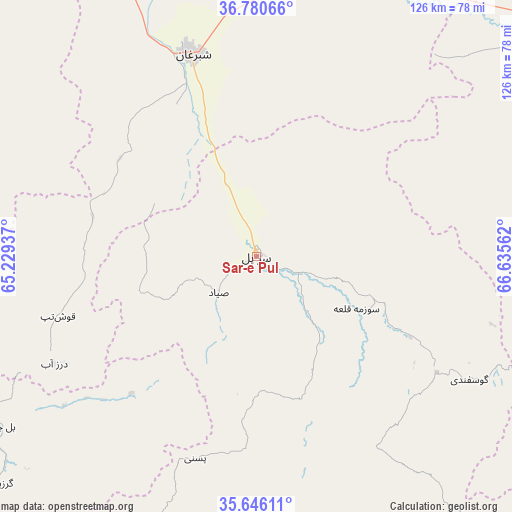
Sar-e Pul GPS coordinates[2]
36° 12' 55.584" North, 65° 55' 56.964" East
| Map corner | latitude | longitude |
|---|---|---|
| Upper-left | 36.78066°, | 65.22937° |
| Center: | 36.21544°, | 65.93249° |
| Lower-right: | 35.64611°, | 66.63562° |
| Map W x H: | 126.2×126.2 km | = 78.4×78.4mi |
| max Lat: | 38.4435° ⇑20.9% North |
| Sar-e Pul: | 36.21544° |
| min Lat: | ⇓79.1% South 30.15° |
| min Long | Sar-e Pul | max Long |
| 61.06667° | 65.93249° | 72.318° |
| W 27.3%⇐ | ⇒72.7% E |
Elevation
Elevation of Sar-e Pul is 636 m = 2087 ft, and this is 782.4 m = 2567 ft below average elevation for this country.
| Max E: |
3068 m = 10066 ft | 83.3% |
| Avg. | 1418.4 m = 4654 ft | |
| Sar-e Pul | 636 m = 2087 ft | |
Min E: |
254 m = 833 ft | 16.7% |
See also: Sar-e Pul elevation on elevation.city.
Geographical zone
Sar-e Pul is located in North temperate zone (between Tropic of Cancer and the Arctic Circle). Distance of this Northern Tropic circle is 1420.9 km =882.9 mi to South.| Distance of | km | miles | from Sar-e Pul |
|---|---|---|---|
| North Pole | 5980.3 | 3716 | to North |
| Arctic Circle | 3374.4 | 2096.8 | to North |
| Tropic Cancer | 1420.9 | 882.9 | to South |
| Equator | 4026.8 | 2502.1 | to South |


Nearby cities:
15 places around Sar-e Pul: (largest is in red/bold)
• Bal Chirāgh
75.6 km =47 mi,  236°
236°
• Darzāb
56.4 km =35 mi, 242°
• Faīẕābād
82.1 km =51 mi,  34°
34°
• Khwājah Dū Kōh
73.5 km =45.7 mi,  338°
338°
• Khānaqāh
75 km =46.6 mi,  16°
16°
• Pasnay
52.1 km =32.4 mi,  196°
196°
• Qal‘ah-ye Shahr
81.2 km =50.5 mi, 203°
• Sang-e Chārak
60.9 km =37.8 mi,  131°
131°
• Shibirghān
52.8 km =32.8 mi, 342°
• Sōzmah Qal‘ah
27.9 km =17.3 mi,  117°
117°
• Tagāw-Bāy
58.5 km =36.4 mi,  168°
168°
• Tukzār
53 km =32.9 mi, 124°
• Āq Kupruk
82.8 km =51.4 mi,  100°
100°
• Āqchah
79.9 km =49.6 mi, 16°
• Şayād
12.8 km =8 mi,  225°
225°
Sources, notices
• [Note1] Compared only with cities in Afghanistan existing in our database
• [Src1] Map data: © OpenStreetMap contributors (CC-BY-SA)
• [Src2] Other city data from geonames.org with taken over terms of usage.
• [Src3] Geographical zone / Annual Mean Temperature by Robert A. Rohde @ Wikipedia
