Qal‘ah-ye Shahr geodata
Qal‘ah-ye Shahr (Sar-e Pol) is a populated place; located in Afghanistan in Asia/Kabul (GMT+4.5) time zone. With population of 7,756 people, there are 78 cities with bigger population in this country. Compared to other cities in Afghanistan, 68.8% of cities are located further ↓South; 76.5% of cities are located further →East and 80.4% of cities have lower elevation than Qal‘ah-ye Shahr. Note1


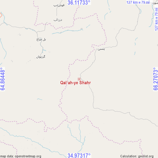
Qal‘ah-ye Shahr GPS coordinates[2]
35° 32' 50.244" North, 65° 34' 3.36" East
| Map corner | latitude | longitude |
|---|---|---|
| Upper-left | 36.11733°, | 64.86448° |
| Center: | 35.54729°, | 65.5676° |
| Lower-right: | 34.97317°, | 66.27073° |
| Map W x H: | 127.2×127.2 km | = 79×79mi |
| max Lat: | 38.4435° ⇑31.2% North |
| Qal‘ah-ye Shahr: | 35.54729° |
| min Lat: | ⇓68.8% South 30.15° |
| min Long | Qal‘ah-ye Sha | max Long |
| 61.06667° | 65.5676° | 72.318° |
| W 23.5%⇐ | ⇒76.5% E |
Elevation
Elevation of Qal‘ah-ye Shahr is 2136 m = 7008 ft, and this is 717.6 m = 2354 ft above average elevation for this country.
| Max E: |
3068 m = 10066 ft | 19.6% |
| Qal‘ah-ye Shahr | 2136 m 7008 ft | |
| Avg. | 1418.4 m = 4654 ft | |
Min E: |
254 m = 833 ft | 80.4% |
See also: Afghanistan elevation on elevation.city.
Geographical zone
Qal‘ah-ye Shahr is located in North temperate zone (between Tropic of Cancer and the Arctic Circle). Distance of this Northern Tropic circle is 1346.6 km =836.7 mi to South.| Distance of | km | miles | from Qal‘ah-ye Shahr |
|---|---|---|---|
| North Pole | 6054.6 | 3762.2 | to North |
| Arctic Circle | 3448.7 | 2142.9 | to North |
| Tropic Cancer | 1346.6 | 836.7 | to South |
| Equator | 3952.5 | 2456 | to South |


Nearby cities:
15 places around Qal‘ah-ye Shahr: (largest is in red/bold)
• Bal Chirāgh
44.6 km =27.7 mi,  316°
316°
• Chīras
40.3 km =25 mi,  111°
111°
• Darzāb
50.8 km =31.6 mi,  340°
340°
• Larkird
99.4 km =61.8 mi,  93°
93°
• Lāsh
74.2 km =46.1 mi,  255°
255°
• Maymana
82.1 km =51 mi,  300°
300°
• Pasnay
30.2 km =18.8 mi,  36°
36°
• Sang-e Chārak
85.4 km =53.1 mi,  66°
66°
• Sar Chakān
35 km =21.7 mi, 299°
• Sar-e Pul
81.2 km =50.5 mi,  23°
23°
• Sōzmah Qal‘ah
84.3 km =52.4 mi, 43°
• Tagāw-Bāy
47.7 km =29.6 mi, 69°
• Tukzār
89 km =55.3 mi,  59°
59°
• Şayād
69.5 km =43.2 mi, 19°
• ‘Alāqahdārī-ye Almār
99.3 km =61.7 mi,  289°
289°
Sources, notices
• [Note1] Compared only with cities in Afghanistan existing in our database
• [Src1] Map data: © OpenStreetMap contributors (CC-BY-SA)
• [Src2] Other city data from geonames.org with taken over terms of usage.
• [Src3] Geographical zone / Annual Mean Temperature by Robert A. Rohde @ Wikipedia
