Āqchah geodata
Āqchah (Jowzjan) is a seat of a second-order administrative division; located in Afghanistan in Asia/Kabul (GMT+4.5) time zone. In our database, there are 93 cities with bigger population. Compared to other cities in Afghanistan, 89.4% of cities are located further ↓South; 69.5% of cities are located further →East and 98.4% of cities have higher elevation than Āqchah. Note1


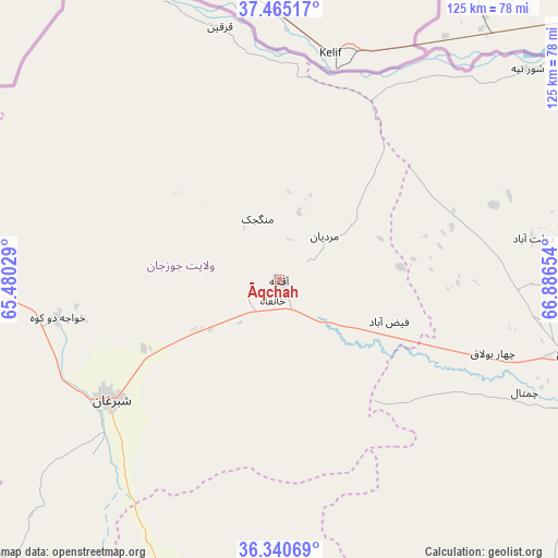
Āqchah GPS coordinates[2]
36° 54' 18" North, 66° 11' 0.276" East
| Map corner | latitude | longitude |
|---|---|---|
| Upper-left | 37.46517°, | 65.48029° |
| Center: | 36.905°, | 66.18341° |
| Lower-right: | 36.34069°, | 66.88654° |
| Map W x H: | 125×125 km | = 77.7×77.7mi |
| max Lat: | 38.4435° ⇑10.6% North |
| Āqchah: | 36.905° |
| min Lat: | ⇓89.4% South 30.15° |
| min Long | Āqchah | max Long |
| 61.06667° | 66.18341° | 72.318° |
| W 30.5%⇐ | ⇒69.5% E |
Elevation
Elevation of Āqchah is 293 m = 961 ft, and this is 1125.4 m = 3692 ft below average elevation for this country.
| Max E: |
3068 m = 10066 ft | 98.4% |
| Avg. | 1418.4 m = 4654 ft | |
| Āqchah | 293 m = 961 ft | |
Min E: |
254 m = 833 ft | 1.6% |
See also: Afghanistan elevation on elevation.city.
Geographical zone
Āqchah is located in North temperate zone (between Tropic of Cancer and the Arctic Circle). Distance of this Northern Tropic circle is 1497.5 km =930.5 mi to South.| Distance of | km | miles | from Āqchah |
|---|---|---|---|
| North Pole | 5903.6 | 3668.3 | to North |
| Arctic Circle | 3297.7 | 2049.1 | to North |
| Tropic Cancer | 1497.5 | 930.5 | to South |
| Equator | 4103.5 | 2549.8 | to South |


Nearby cities:
15 places around Āqchah: (largest is in red/bold)
• Balkh
65.6 km =40.8 mi,  104°
104°
• Chimtāl
60.7 km =37.7 mi,  114°
114°
• Dehdādī
77 km =47.8 mi, 110°
• Dowlatābād
57.4 km =35.7 mi,  80°
80°
• Faīẕābād
26.3 km =16.3 mi, 110°
• Khamyāb
78.8 km =49 mi,  331°
331°
• Khwājah Dū Kōh
50.5 km =31.4 mi,  260°
260°
• Khānaqāh
4.9 km =3 mi,  197°
197°
• Mardīān
14 km =8.7 mi,  45°
45°
• Mazār-e Sharīf
85.4 km =53.1 mi, 104°
• Mingajik
14.5 km =9 mi,  340°
340°
• Qarchī Gak
55.8 km =34.7 mi,  74°
74°
• Qarqīn
58.4 km =36.3 mi,  347°
347°
• Sar-e Pul
79.9 km =49.6 mi, 196°
• Shibirghān
46.5 km =28.9 mi,  235°
235°
Sources, notices
• [Note1] Compared only with cities in Afghanistan existing in our database
• [Src1] Map data: © OpenStreetMap contributors (CC-BY-SA)
• [Src2] Other city data from geonames.org with taken over terms of usage.
• [Src3] Geographical zone / Annual Mean Temperature by Robert A. Rohde @ Wikipedia
