Khwājah Dū Kōh geodata
Khwājah Dū Kōh (Jowzjan) is a seat of a second-order administrative division; located in Afghanistan in Asia/Kabul (GMT+4.5) time zone. In our database, there are 93 cities with bigger population. Compared to other cities in Afghanistan, 87.5% of cities are located further ↓South; 76.2% of cities are located further →East and 96.8% of cities have higher elevation than Khwājah Dū Kōh. Note1


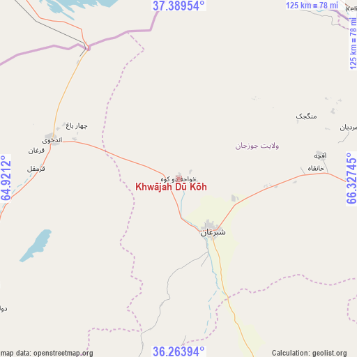
Khwājah Dū Kōh GPS coordinates[2]
36° 49' 43.716" North, 65° 37' 27.552" East
| Map corner | latitude | longitude |
|---|---|---|
| Upper-left | 37.38954°, | 64.9212° |
| Center: | 36.82881°, | 65.62432° |
| Lower-right: | 36.26394°, | 66.32745° |
| Map W x H: | 125.2×125.2 km | = 77.8×77.8mi |
| max Lat: | 38.4435° ⇑12.5% North |
| Khwājah Dū Kōh: | 36.82881° |
| min Lat: | ⇓87.5% South 30.15° |
| min Long | Khwājah Dū K� | max Long |
| 61.06667° | 65.62432° | 72.318° |
| W 23.8%⇐ | ⇒76.2% E |
Elevation
Elevation of Khwājah Dū Kōh is 307 m = 1007 ft, and this is 1111.4 m = 3646 ft below average elevation for this country.
| Max E: |
3068 m = 10066 ft | 96.8% |
| Avg. | 1418.4 m = 4654 ft | |
| Khwājah Dū Kōh | 307 m = 1007 ft | |
Min E: |
254 m = 833 ft | 3.2% |
See also: Afghanistan elevation on elevation.city.
Geographical zone
Khwājah Dū Kōh is located in North temperate zone (between Tropic of Cancer and the Arctic Circle). Distance of this Northern Tropic circle is 1489.1 km =925.3 mi to South.| Distance of | km | miles | from Khwājah Dū Kōh |
|---|---|---|---|
| North Pole | 5912.1 | 3673.6 | to North |
| Arctic Circle | 3306.2 | 2054.4 | to North |
| Tropic Cancer | 1489.1 | 925.3 | to South |
| Equator | 4095 | 2544.5 | to South |


Nearby cities:
15 places around Khwājah Dū Kōh: (largest is in red/bold)
• Andkhōy
46.6 km =29 mi,  287°
287°
• Chahār Bāgh
40.4 km =25.1 mi,  298°
298°
• Dowlatābād
76.7 km =47.7 mi,  234°
234°
• Faīẕābād
74.3 km =46.2 mi,  90°
90°
• Khamyāb
78.6 km =48.8 mi,  8°
8°
• Khānaqāh
48.4 km =30.1 mi, 85°
• Mardīān
62.5 km =38.8 mi,  73°
73°
• Mingajik
50 km =31.1 mi,  63°
63°
• Qaram Qōl
51.7 km =32.1 mi,  270°
270°
• Qarqīn
75.4 km =46.9 mi,  29°
29°
• Qurghān
50.8 km =31.6 mi,  281°
281°
• Sar-e Pul
73.5 km =45.7 mi,  158°
158°
• Shibirghān
21.3 km =13.2 mi,  147°
147°
• Āqchah
50.5 km =31.4 mi,  80°
80°
• Şayād
79.3 km =49.3 mi,  166°
166°
Sources, notices
• [Note1] Compared only with cities in Afghanistan existing in our database
• [Src1] Map data: © OpenStreetMap contributors (CC-BY-SA)
• [Src2] Other city data from geonames.org with taken over terms of usage.
• [Src3] Geographical zone / Annual Mean Temperature by Robert A. Rohde @ Wikipedia
