Shibirghān geodata
Shibirghān (Jowzjan) is a seat of a first-order administrative division; located in Afghanistan in Asia/Kabul (GMT+4.5) time zone. With population of 55,641 people, there are 18 cities with bigger population in this country. Compared to other cities in Afghanistan, 83.3% of cities are located further ↓South; 74.6% of cities are located further →East and 93.9% of cities have higher elevation than Shibirghān. Note1


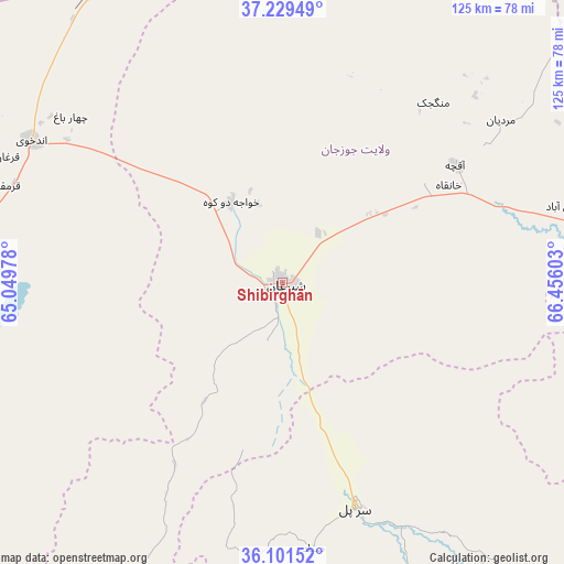
Shibirghān GPS coordinates[2]
36° 40' 3.252" North, 65° 45' 10.44" East
| Map corner | latitude | longitude |
|---|---|---|
| Upper-left | 37.22949°, | 65.04978° |
| Center: | 36.66757°, | 65.7529° |
| Lower-right: | 36.10152°, | 66.45603° |
| Map W x H: | 125.4×125.4 km | = 77.9×77.9mi |
| max Lat: | 38.4435° ⇑16.7% North |
| Shibirghān: | 36.66757° |
| min Lat: | ⇓83.3% South 30.15° |
| min Long | Shibirghān | max Long |
| 61.06667° | 65.7529° | 72.318° |
| W 25.4%⇐ | ⇒74.6% E |
Elevation
Elevation of Shibirghān is 360 m = 1181 ft, and this is 1058.4 m = 3472 ft below average elevation for this country.
| Max E: |
3068 m = 10066 ft | 93.9% |
| Avg. | 1418.4 m = 4654 ft | |
| Shibirghān | 360 m = 1181 ft | |
Min E: |
254 m = 833 ft | 6.1% |
See also: Shibirghān elevation on elevation.city.
Geographical zone
Shibirghān is located in North temperate zone (between Tropic of Cancer and the Arctic Circle). Distance of this Northern Tropic circle is 1471.1 km =914.1 mi to South.| Distance of | km | miles | from Shibirghān |
|---|---|---|---|
| North Pole | 5930 | 3684.7 | to North |
| Arctic Circle | 3324.1 | 2065.5 | to North |
| Tropic Cancer | 1471.1 | 914.1 | to South |
| Equator | 4077.1 | 2533.4 | to South |


Nearby cities:
15 places around Shibirghān: (largest is in red/bold)
• Andkhōy
64.4 km =40 mi,  299°
299°
• Chahār Bāgh
59.9 km =37.2 mi,  308°
308°
• Darzāb
83.8 km =52.1 mi,  203°
203°
• Dowlatābād
78.8 km =49 mi,  250°
250°
• Faīẕābād
65.2 km =40.5 mi,  74°
74°
• Khwājah Dū Kōh
21.3 km =13.2 mi,  327°
327°
• Khānaqāh
42.8 km =26.6 mi,  59°
59°
• Mardīān
60.4 km =37.5 mi,  53°
53°
• Mingajik
52.2 km =32.4 mi,  39°
39°
• Qaram Qōl
65.8 km =40.9 mi,  285°
285°
• Qurghān
67.4 km =41.9 mi, 294°
• Sar-e Pul
52.8 km =32.8 mi,  162°
162°
• Sōzmah Qal‘ah
75.2 km =46.7 mi,  147°
147°
• Āqchah
46.5 km =28.9 mi, 55°
• Şayād
59.6 km =37 mi,  173°
173°
Sources, notices
• [Note1] Compared only with cities in Afghanistan existing in our database
• [Src1] Map data: © OpenStreetMap contributors (CC-BY-SA)
• [Src2] Other city data from geonames.org with taken over terms of usage.
• [Src3] Geographical zone / Annual Mean Temperature by Robert A. Rohde @ Wikipedia
