Şayād geodata
Şayād (Sar-e Pol) is a seat of a second-order administrative division; located in Afghanistan in Asia/Kabul (GMT+4.5) time zone. In our database, there are 93 cities with bigger population. Compared to other cities in Afghanistan, 78.8% of cities are located further ↓South; 73.3% of cities are located further →East and 68.5% of cities have higher elevation than Şayād. Note1


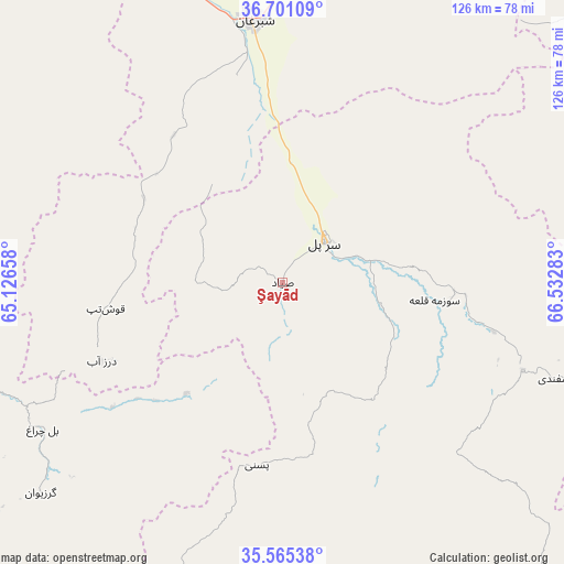
Şayād GPS coordinates[2]
36° 8' 7.044" North, 65° 49' 46.92" East
| Map corner | latitude | longitude |
|---|---|---|
| Upper-left | 36.70109°, | 65.12658° |
| Center: | 36.13529°, | 65.8297° |
| Lower-right: | 35.56538°, | 66.53283° |
| Map W x H: | 126.3×126.3 km | = 78.5×78.5mi |
| max Lat: | 38.4435° ⇑21.2% North |
| Şayād: | 36.13529° |
| min Lat: | ⇓78.8% South 30.15° |
| min Long | Şayād | max Long |
| 61.06667° | 65.8297° | 72.318° |
| W 26.7%⇐ | ⇒73.3% E |
Elevation
Elevation of Şayād is 946 m = 3104 ft, and this is 472.4 m = 1550 ft below average elevation for this country.
| Max E: |
3068 m = 10066 ft | 68.5% |
| Avg. | 1418.4 m = 4654 ft | |
| Şayād | 946 m = 3104 ft | |
Min E: |
254 m = 833 ft | 31.5% |
See also: Afghanistan elevation on elevation.city.
Geographical zone
Şayād is located in North temperate zone (between Tropic of Cancer and the Arctic Circle). Distance of this Northern Tropic circle is 1411.9 km =877.3 mi to South.| Distance of | km | miles | from Şayād |
|---|---|---|---|
| North Pole | 5989.2 | 3721.5 | to North |
| Arctic Circle | 3383.3 | 2102.3 | to North |
| Tropic Cancer | 1411.9 | 877.3 | to South |
| Equator | 4017.9 | 2496.6 | to South |


Nearby cities:
15 places around Şayād: (largest is in red/bold)
• Bal Chirāgh
63.1 km =39.2 mi,  238°
238°
• Chīras
81.1 km =50.4 mi,  170°
170°
• Darzāb
44.2 km =27.5 mi,  246°
246°
• Dowlatābād
87.9 km =54.6 mi,  292°
292°
• Khwājah Dū Kōh
79.3 km =49.3 mi,  346°
346°
• Khānaqāh
86.3 km =53.6 mi,  20°
20°
• Pasnay
41.4 km =25.7 mi,  188°
188°
• Qal‘ah-ye Shahr
69.5 km =43.2 mi,  199°
199°
• Sang-e Chārak
63.2 km =39.3 mi,  120°
120°
• Sar Chakān
72.3 km =44.9 mi,  228°
228°
• Sar-e Pul
12.8 km =8 mi,  45°
45°
• Shibirghān
59.6 km =37 mi, 353°
• Sōzmah Qal‘ah
34.2 km =21.3 mi,  96°
96°
• Tagāw-Bāy
52.8 km =32.8 mi,  156°
156°
• Tukzār
57.1 km =35.5 mi,  111°
111°
Sources, notices
• [Note1] Compared only with cities in Afghanistan existing in our database
• [Src1] Map data: © OpenStreetMap contributors (CC-BY-SA)
• [Src2] Other city data from geonames.org with taken over terms of usage.
• [Src3] Geographical zone / Annual Mean Temperature by Robert A. Rohde @ Wikipedia
