Sang-e Chārak geodata
Sang-e Chārak (Sar-e Pol) is a populated place; located in Afghanistan in Asia/Kabul (GMT+4.5) time zone. With population of 15,377 people, there are 43 cities with bigger population in this country. Compared to other cities in Afghanistan, 74.3% of cities are located further ↓South; 66.6% of cities are located further →East and 53.4% of cities have lower elevation than Sang-e Chārak. Note1


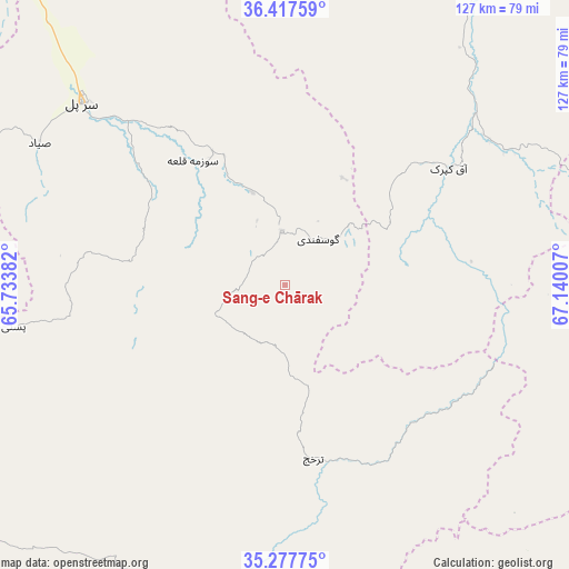
Sang-e Chārak GPS coordinates[2]
35° 50' 58.992" North, 66° 26' 12.984" East
| Map corner | latitude | longitude |
|---|---|---|
| Upper-left | 36.41759°, | 65.73382° |
| Center: | 35.84972°, | 66.43694° |
| Lower-right: | 35.27775°, | 67.14007° |
| Map W x H: | 126.7×126.7 km | = 78.7×78.7mi |
| max Lat: | 38.4435° ⇑25.7% North |
| Sang-e Chārak: | 35.84972° |
| min Lat: | ⇓74.3% South 30.15° |
| min Long | Sang-e Chārak | max Long |
| 61.06667° | 66.43694° | 72.318° |
| W 33.4%⇐ | ⇒66.6% E |
Elevation
Elevation of Sang-e Chārak is 1483 m = 4865 ft, and this is 64.6 m = 212 ft above average elevation for this country.
| Max E: |
3068 m = 10066 ft | 46.6% |
| Sang-e Chārak | 1483 m 4865 ft | |
| Avg. | 1418.4 m = 4654 ft | |
Min E: |
254 m = 833 ft | 53.4% |
See also: Afghanistan elevation on elevation.city.
Geographical zone
Sang-e Chārak is located in North temperate zone (between Tropic of Cancer and the Arctic Circle). Distance of this Northern Tropic circle is 1380.2 km =857.6 mi to South.| Distance of | km | miles | from Sang-e Chārak |
|---|---|---|---|
| North Pole | 6020.9 | 3741.2 | to North |
| Arctic Circle | 3415.1 | 2122 | to North |
| Tropic Cancer | 1380.2 | 857.6 | to South |
| Equator | 3986.1 | 2476.8 | to South |


Nearby cities:
15 places around Sang-e Chārak: (largest is in red/bold)
• Chimtāl
97.8 km =60.8 mi,  19°
19°
• Chīras
63.3 km =39.3 mi,  220°
220°
• Darzāb
96.4 km =59.9 mi,  278°
278°
• Dehdādī
103.3 km =64.2 mi,  28°
28°
• Dehī
76.9 km =47.8 mi,  80°
80°
• Lab-Sar
41.1 km =25.5 mi,  61°
61°
• Larkird
45 km =28 mi,  152°
152°
• Pasnay
61.3 km =38.1 mi,  261°
261°
• Qal‘ah-ye Shahr
85.4 km =53.1 mi,  246°
246°
• Sar-e Pul
60.9 km =37.8 mi,  311°
311°
• Sōzmah Qal‘ah
34.5 km =21.4 mi,  323°
323°
• Tagāw-Bāy
37.8 km =23.5 mi,  243°
243°
• Tukzār
11.1 km =6.9 mi,  352°
352°
• Āq Kupruk
44.6 km =27.7 mi,  54°
54°
• Şayād
63.2 km =39.3 mi,  300°
300°
Sources, notices
• [Note1] Compared only with cities in Afghanistan existing in our database
• [Src1] Map data: © OpenStreetMap contributors (CC-BY-SA)
• [Src2] Other city data from geonames.org with taken over terms of usage.
• [Src3] Geographical zone / Annual Mean Temperature by Robert A. Rohde @ Wikipedia
