Rū-ye Sang geodata
Rū-ye Sang (Bamyan) is a seat of a second-order administrative division; located in Afghanistan in Asia/Kabul (GMT+4.5) time zone. In our database, there are 93 cities with bigger population. Compared to other cities in Afghanistan, 66.6% of cities are located further ↓South; 58.2% of cities are located further →East and 64.3% of cities have lower elevation than Rū-ye Sang. Note1


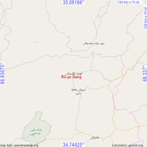
Rū-ye Sang GPS coordinates[2]
35° 19' 11.964" North, 67° 38' 1.932" East
| Map corner | latitude | longitude |
|---|---|---|
| Upper-left | 35.89166°, | 66.93075° |
| Center: | 35.31999°, | 67.63387° |
| Lower-right: | 34.74425°, | 68.337° |
| Map W x H: | 127.6×127.6 km | = 79.3×79.3mi |
| max Lat: | 38.4435° ⇑33.4% North |
| Rū-ye Sang: | 35.31999° |
| min Lat: | ⇓66.6% South 30.15° |
| min Long | Rū-ye Sang | max Long |
| 61.06667° | 67.63387° | 72.318° |
| W 41.8%⇐ | ⇒58.2% E |
Elevation
Elevation of Rū-ye Sang is 1751 m = 5745 ft, and this is 332.6 m = 1091 ft above average elevation for this country.
| Max E: |
3068 m = 10066 ft | 35.7% |
| Rū-ye Sang | 1751 m 5745 ft | |
| Avg. | 1418.4 m = 4654 ft | |
Min E: |
254 m = 833 ft | 64.3% |
See also: Afghanistan elevation on elevation.city.
Geographical zone
Rū-ye Sang is located in North temperate zone (between Tropic of Cancer and the Arctic Circle). Distance of this Northern Tropic circle is 1321.3 km =821 mi to South.| Distance of | km | miles | from Rū-ye Sang |
|---|---|---|---|
| North Pole | 6079.8 | 3777.8 | to North |
| Arctic Circle | 3474 | 2158.6 | to North |
| Tropic Cancer | 1321.3 | 821 | to South |
| Equator | 3927.2 | 2440.2 | to South |


Nearby cities:
15 places around Rū-ye Sang: (largest is in red/bold)
• Aībak
110.5 km =68.7 mi,  18°
18°
• Bulōlah
64.3 km =40 mi,  140°
140°
• Bāmyān
58.1 km =36.1 mi,  162°
162°
• Bāzār-e Tālah
54 km =33.6 mi,  81°
81°
• Dahan-e Jarf
87 km =54.1 mi,  119°
119°
• Dehī
77.8 km =48.3 mi,  335°
335°
• Dōshī
100.5 km =62.4 mi,  71°
71°
• Dūāb
31.9 km =19.8 mi,  32°
32°
• Khudāydād Khēl
16.5 km =10.3 mi, 162°
• Lab-Sar
106.5 km =66.2 mi,  317°
317°
• Langar
83.9 km =52.1 mi, 26°
• Larkird
89.9 km =55.9 mi,  282°
282°
• Nayak
89.9 km =55.9 mi,  223°
223°
• Āq Kupruk
111.1 km =69 mi, 319°
• Ḩukūmatī Dahanah-ye Ghōrī
101.1 km =62.8 mi,  49°
49°
Sources, notices
• [Note1] Compared only with cities in Afghanistan existing in our database
• [Src1] Map data: © OpenStreetMap contributors (CC-BY-SA)
• [Src2] Other city data from geonames.org with taken over terms of usage.
• [Src3] Geographical zone / Annual Mean Temperature by Robert A. Rohde @ Wikipedia
