Lab-Sar geodata
Lab-Sar (Balkh) is a populated place; located in Afghanistan in Asia/Kabul (GMT+4.5) time zone. With population of 1,068 people, there are 90 cities with bigger population in this country. Compared to other cities in Afghanistan, 76.8% of cities are located further ↓South; 63% of cities are located further →East and 65.3% of cities have higher elevation than Lab-Sar. Note1


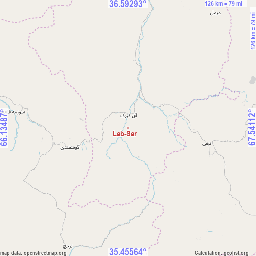
Lab-Sar GPS coordinates[2]
36° 1' 34.824" North, 66° 50' 16.764" East
| Map corner | latitude | longitude |
|---|---|---|
| Upper-left | 36.59293°, | 66.13487° |
| Center: | 36.02634°, | 66.83799° |
| Lower-right: | 35.45564°, | 67.54112° |
| Map W x H: | 126.5×126.5 km | = 78.6×78.6mi |
| max Lat: | 38.4435° ⇑23.2% North |
| Lab-Sar: | 36.02634° |
| min Lat: | ⇓76.8% South 30.15° |
| min Long | Lab-Sar | max Long |
| 61.06667° | 66.83799° | 72.318° |
| W 37%⇐ | ⇒63% E |
Elevation
Elevation of Lab-Sar is 1011 m = 3317 ft, and this is 407.4 m = 1337 ft below average elevation for this country.
| Max E: |
3068 m = 10066 ft | 65.3% |
| Avg. | 1418.4 m = 4654 ft | |
| Lab-Sar | 1011 m = 3317 ft | |
Min E: |
254 m = 833 ft | 34.7% |
See also: Afghanistan elevation on elevation.city.
Geographical zone
Lab-Sar is located in North temperate zone (between Tropic of Cancer and the Arctic Circle). Distance of this Northern Tropic circle is 1399.8 km =869.8 mi to South.| Distance of | km | miles | from Lab-Sar |
|---|---|---|---|
| North Pole | 6001.3 | 3729 | to North |
| Arctic Circle | 3395.4 | 2109.8 | to North |
| Tropic Cancer | 1399.8 | 869.8 | to South |
| Equator | 4005.8 | 2489.1 | to South |


Nearby cities:
15 places around Lab-Sar: (largest is in red/bold)
• Balkh
81.3 km =50.5 mi,  3°
3°
• Chimtāl
72.5 km =45 mi,  357°
357°
• Dehdādī
72.2 km =44.9 mi,  11°
11°
• Dehī
40.5 km =25.2 mi,  100°
100°
• Faīẕābād
94.6 km =58.8 mi,  339°
339°
• Larkird
61.7 km =38.3 mi,  194°
194°
• Mazār-e Sharīf
79.7 km =49.5 mi,  17°
17°
• Pasnay
100.9 km =62.7 mi,  253°
253°
• Sang-e Chārak
41.1 km =25.5 mi,  241°
241°
• Sar-e Pul
84 km =52.2 mi,  284°
284°
• Sōzmah Qal‘ah
57.2 km =35.5 mi, 278°
• Tagāw-Bāy
78.8 km =49 mi, 242°
• Tukzār
38.5 km =23.9 mi,  256°
256°
• Āq Kupruk
6.4 km =4 mi, 1°
• Şayād
91.4 km =56.8 mi, 277°
Sources, notices
• [Note1] Compared only with cities in Afghanistan existing in our database
• [Src1] Map data: © OpenStreetMap contributors (CC-BY-SA)
• [Src2] Other city data from geonames.org with taken over terms of usage.
• [Src3] Geographical zone / Annual Mean Temperature by Robert A. Rohde @ Wikipedia
