Qarāwul geodata
Qarāwul (Kunduz) is a populated place; located in Afghanistan in Asia/Kabul (GMT+4.5) time zone. With population of 24,544 people, there are 33 cities with bigger population in this country. Compared to other cities in Afghanistan, 96.1% of cities are located further ↓South; 53.7% of cities are located further ←West and 95.2% of cities have higher elevation than Qarāwul. Note1


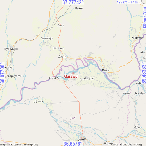
Qarāwul GPS coordinates[2]
37° 13' 10.524" North, 68° 46' 48.72" East
| Map corner | latitude | longitude |
|---|---|---|
| Upper-left | 37.77742°, | 68.07708° |
| Center: | 37.21959°, | 68.7802° |
| Lower-right: | 36.6576°, | 69.48333° |
| Map W x H: | 124.5×124.5 km | = 77.4×77.4mi |
| max Lat: | 38.4435° ⇑3.9% North |
| Qarāwul: | 37.21959° |
| min Lat: | ⇓96.1% South 30.15° |
| min Long | Qarāwul | max Long |
| 61.06667° | 68.7802° | 72.318° |
| W 53.7%⇐ | ⇒46.3% E |
Elevation
Elevation of Qarāwul is 337 m = 1106 ft, and this is 1081.4 m = 3548 ft below average elevation for this country.
| Max E: |
3068 m = 10066 ft | 95.2% |
| Avg. | 1418.4 m = 4654 ft | |
| Qarāwul | 337 m = 1106 ft | |
Min E: |
254 m = 833 ft | 4.8% |
See also: Afghanistan elevation on elevation.city.
Geographical zone
Qarāwul is located in North temperate zone (between Tropic of Cancer and the Arctic Circle). Distance of this Northern Tropic circle is 1532.5 km =952.3 mi to South.| Distance of | km | miles | from Qarāwul |
|---|---|---|---|
| North Pole | 5868.6 | 3646.6 | to North |
| Arctic Circle | 3262.7 | 2027.3 | to North |
| Tropic Cancer | 1532.5 | 952.3 | to South |
| Equator | 4138.4 | 2571.5 | to South |


Nearby cities:
15 places around Qarāwul: (largest is in red/bold)
• Afaki
80.1 km =49.8 mi,  140°
140°
• Aliabad
78.4 km =48.7 mi,  172°
172°
• Chāh Āb
93.6 km =58.2 mi,  77°
77°
• Darqad
62.3 km =38.7 mi,  72°
72°
• Dasht-e Archī
35.6 km =22.1 mi,  105°
105°
• Dasht-e Qal‘ah
59.2 km =36.8 mi,  97°
97°
• Dowr-e Rabāţ
58.7 km =36.5 mi,  179°
179°
• Imām Şāḩib
14.2 km =8.8 mi, 103°
• Khanabad
66.7 km =41.4 mi,  153°
153°
• Khwājah Ghār
59.3 km =36.8 mi, 106°
• Kunduz
55 km =34.2 mi, 172°
• Rustāq
93.6 km =58.2 mi, 96°
• Taloqan
85.9 km =53.4 mi,  128°
128°
• Yangī Qal‘ah
78.4 km =48.7 mi, 69°
• Ārt Khwājah
63.7 km =39.6 mi, 103°
Sources, notices
• [Note1] Compared only with cities in Afghanistan existing in our database
• [Src1] Map data: © OpenStreetMap contributors (CC-BY-SA)
• [Src2] Other city data from geonames.org with taken over terms of usage.
• [Src3] Geographical zone / Annual Mean Temperature by Robert A. Rohde @ Wikipedia
