Kunduz geodata
Kunduz is a seat of a first-order administrative division; located in Afghanistan in Asia/Kabul (GMT+4.5) time zone. With population of 161,902 people, there are 5 cities with bigger population in this country. Compared to other cities in Afghanistan, 85.5% of cities are located further ↓South; 55.6% of cities are located further ←West and 92.3% of cities have higher elevation than Kunduz. Note1


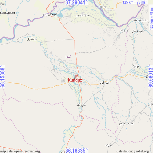
Kunduz GPS coordinates[2]
36° 43' 44.22" North, 68° 51' 25.2" East
| Map corner | latitude | longitude |
|---|---|---|
| Upper-left | 37.29041°, | 68.15388° |
| Center: | 36.72895°, | 68.857° |
| Lower-right: | 36.16335°, | 69.56013° |
| Map W x H: | 125.3×125.3 km | = 77.9×77.9mi |
| max Lat: | 38.4435° ⇑14.5% North |
| Kunduz: | 36.72895° |
| min Lat: | ⇓85.5% South 30.15° |
| min Long | Kunduz | max Long |
| 61.06667° | 68.857° | 72.318° |
| W 55.6%⇐ | ⇒44.4% E |
Elevation
Elevation of Kunduz is 402 m = 1319 ft, and this is 1016.4 m = 3335 ft below average elevation for this country.
| Max E: |
3068 m = 10066 ft | 92.3% |
| Avg. | 1418.4 m = 4654 ft | |
| Kunduz | 402 m = 1319 ft | |
Min E: |
254 m = 833 ft | 7.7% |
See also: Kunduz elevation on elevation.city.
Geographical zone
Kunduz is located in North temperate zone (between Tropic of Cancer and the Arctic Circle). Distance of this Northern Tropic circle is 1478 km =918.4 mi to South.| Distance of | km | miles | from Kunduz |
|---|---|---|---|
| North Pole | 5923.2 | 3680.5 | to North |
| Arctic Circle | 3317.3 | 2061.3 | to North |
| Tropic Cancer | 1478 | 918.4 | to South |
| Equator | 4083.9 | 2537.6 | to South |


Nearby cities:
15 places around Kunduz: (largest is in red/bold)
• Afaki
44.7 km =27.8 mi,  99°
99°
• Aliabad
23.4 km =14.5 mi,  170°
170°
• Baghlān
67.8 km =42.1 mi,  191°
191°
• Būrkah
62.1 km =38.6 mi,  155°
155°
• Dasht-e Archī
52.7 km =32.7 mi,  31°
31°
• Dasht-e Qal‘ah
70.4 km =43.7 mi,  47°
47°
• Dowr-e Rabāţ
7.2 km =4.5 mi,  234°
234°
• Imām Şāḩib
51.6 km =32.1 mi,  7°
7°
• Khanabad
23.6 km =14.7 mi, 102°
• Khwājah Ghār
62.6 km =38.9 mi, 53°
• Khānaqāh
61.7 km =38.3 mi, 100°
• Qarāwul
55 km =34.2 mi,  352°
352°
• Taloqan
60.4 km =37.5 mi,  89°
89°
• Ārt Khwājah
68.1 km =42.3 mi, 54°
• Ţāqchah Khānah
69.8 km =43.4 mi, 100°
In other languages:
- In Spanish: Qundūz
- In France: Kondôz
- In German: Kundus
- In Italian: Konduz
- In Russian: Кундуз
- In Chinese: 昆都士
Sources, notices
• [Note1] Compared only with cities in Afghanistan existing in our database
• [Src1] Map data: © OpenStreetMap contributors (CC-BY-SA)
• [Src2] Other city data from geonames.org with taken over terms of usage.
• [Src3] Geographical zone / Annual Mean Temperature by Robert A. Rohde @ Wikipedia
