Yangī Qal‘ah geodata
Yangī Qal‘ah (Takhar) is a populated place; located in Afghanistan in Asia/Kabul (GMT+4.5) time zone. With population of 6,541 people, there are 83 cities with bigger population in this country. Compared to other cities in Afghanistan, 97.4% of cities are located further ↓South; 75.9% of cities are located further ←West and 89.7% of cities have higher elevation than Yangī Qal‘ah. Note1


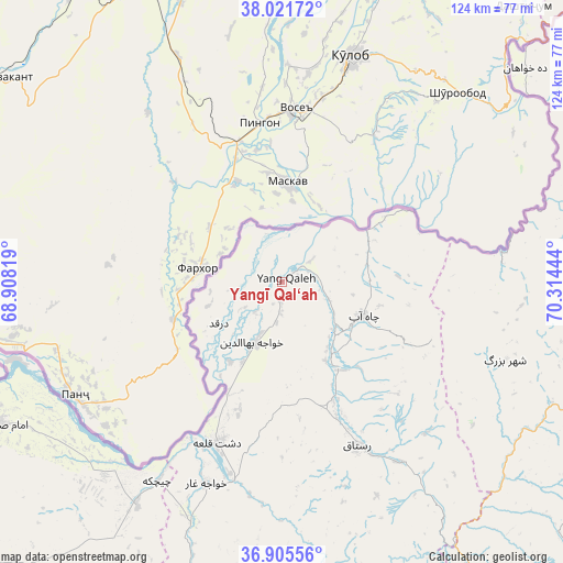
Yangī Qal‘ah GPS coordinates[2]
37° 27' 56.592" North, 69° 36' 40.716" East
| Map corner | latitude | longitude |
|---|---|---|
| Upper-left | 38.02172°, | 68.90819° |
| Center: | 37.46572°, | 69.61131° |
| Lower-right: | 36.90556°, | 70.31444° |
| Map W x H: | 124.1×124.1 km | = 77.1×77.1mi |
| max Lat: | 38.4435° ⇑2.6% North |
| Yangī Qal‘ah: | 37.46572° |
| min Lat: | ⇓97.4% South 30.15° |
| min Long | Yangī Qal‘ah | max Long |
| 61.06667° | 69.61131° | 72.318° |
| W 75.9%⇐ | ⇒24.1% E |
Elevation
Elevation of Yangī Qal‘ah is 471 m = 1545 ft, and this is 947.4 m = 3108 ft below average elevation for this country.
| Max E: |
3068 m = 10066 ft | 89.7% |
| Avg. | 1418.4 m = 4654 ft | |
| Yangī Qal‘ah | 471 m = 1545 ft | |
Min E: |
254 m = 833 ft | 10.3% |
See also: Afghanistan elevation on elevation.city.
Geographical zone
Yangī Qal‘ah is located in North temperate zone (between Tropic of Cancer and the Arctic Circle). Distance of this Northern Tropic circle is 1559.9 km =969.3 mi to South.| Distance of | km | miles | from Yangī Qal‘ah |
|---|---|---|---|
| North Pole | 5841.3 | 3629.6 | to North |
| Arctic Circle | 3235.4 | 2010.4 | to North |
| Tropic Cancer | 1559.9 | 969.3 | to South |
| Equator | 4165.8 | 2588.5 | to South |


Nearby cities:
15 places around Yangī Qal‘ah: (largest is in red/bold)
• Chāh Āb
19.5 km =12.1 mi,  112°
112°
• Darqad
16.7 km =10.4 mi,  237°
237°
• Dasht-e Archī
54 km =33.6 mi,  226°
226°
• Dasht-e Qal‘ah
37.7 km =23.4 mi,  203°
203°
• Deh Khwāhān
71.3 km =44.3 mi,  48°
48°
• Imām Şāḩib
67.1 km =41.7 mi, 242°
• Kalafgān
82.6 km =51.3 mi,  159°
159°
• Khwājah Ghār
47.5 km =29.5 mi, 200°
• March
74.2 km =46.1 mi,  84°
84°
• Mashhad
84.3 km =52.4 mi,  148°
148°
• Qarāwul
78.4 km =48.7 mi,  249°
249°
• Rustāq
42.5 km =26.4 mi, 152°
• Taloqan
81.4 km =50.6 mi,  184°
184°
• Ārt Khwājah
43.8 km =27.2 mi, 195°
• Ḩāfiz̧ Moghul
83.4 km =51.8 mi,  123°
123°
Sources, notices
• [Note1] Compared only with cities in Afghanistan existing in our database
• [Src1] Map data: © OpenStreetMap contributors (CC-BY-SA)
• [Src2] Other city data from geonames.org with taken over terms of usage.
• [Src3] Geographical zone / Annual Mean Temperature by Robert A. Rohde @ Wikipedia
