Imām Şāḩib geodata
Imām Şāḩib (Kunduz) is a seat of a second-order administrative division; located in Afghanistan in Asia/Kabul (GMT+4.5) time zone. With population of 9,659 people, there are 70 cities with bigger population in this country. Compared to other cities in Afghanistan, 95.5% of cities are located further ↓South; 57.2% of cities are located further ←West and 94.2% of cities have higher elevation than Imām Şāḩib. Note1


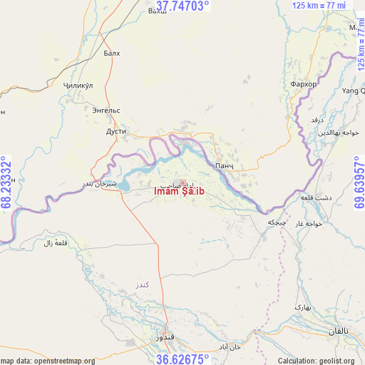
Imām Şāḩib GPS coordinates[2]
37° 11' 20.292" North, 68° 56' 11.184" East
| Map corner | latitude | longitude |
|---|---|---|
| Upper-left | 37.74703°, | 68.23332° |
| Center: | 37.18897°, | 68.93644° |
| Lower-right: | 36.62675°, | 69.63957° |
| Map W x H: | 124.6×124.6 km | = 77.4×77.4mi |
| max Lat: | 38.4435° ⇑4.5% North |
| Imām Şāḩib: | 37.18897° |
| min Lat: | ⇓95.5% South 30.15° |
| min Long | Imām Şāḩib | max Long |
| 61.06667° | 68.93644° | 72.318° |
| W 57.2%⇐ | ⇒42.8% E |
Elevation
Elevation of Imām Şāḩib is 358 m = 1175 ft, and this is 1060.4 m = 3479 ft below average elevation for this country.
| Max E: |
3068 m = 10066 ft | 94.2% |
| Avg. | 1418.4 m = 4654 ft | |
| Imām Şāḩib | 358 m = 1175 ft | |
Min E: |
254 m = 833 ft | 5.8% |
See also: Afghanistan elevation on elevation.city.
Geographical zone
Imām Şāḩib is located in North temperate zone (between Tropic of Cancer and the Arctic Circle). Distance of this Northern Tropic circle is 1529.1 km =950.1 mi to South.| Distance of | km | miles | from Imām Şāḩib |
|---|---|---|---|
| North Pole | 5872 | 3648.7 | to North |
| Arctic Circle | 3266.1 | 2029.5 | to North |
| Tropic Cancer | 1529.1 | 950.1 | to South |
| Equator | 4135 | 2569.4 | to South |


Nearby cities:
15 places around Imām Şāḩib: (largest is in red/bold)
• Afaki
69.2 km =43 mi,  147°
147°
• Aliabad
74.3 km =46.2 mi,  182°
182°
• Chāh Āb
81.1 km =50.4 mi,  73°
73°
• Darqad
50.6 km =31.4 mi,  64°
64°
• Dasht-e Archī
21.3 km =13.2 mi,  106°
106°
• Dasht-e Qal‘ah
45.1 km =28 mi,  94°
94°
• Dowr-e Rabāţ
56.8 km =35.3 mi,  193°
193°
• Khanabad
58.5 km =36.4 mi,  164°
164°
• Khwājah Ghār
45.1 km =28 mi, 107°
• Kunduz
51.6 km =32.1 mi, 187°
• Qarāwul
14.2 km =8.8 mi,  283°
283°
• Rustāq
79.5 km =49.4 mi,  95°
95°
• Taloqan
73.2 km =45.5 mi,  133°
133°
• Yangī Qal‘ah
67.1 km =41.7 mi, 62°
• Ārt Khwājah
49.5 km =30.8 mi, 103°
Sources, notices
• [Note1] Compared only with cities in Afghanistan existing in our database
• [Src1] Map data: © OpenStreetMap contributors (CC-BY-SA)
• [Src2] Other city data from geonames.org with taken over terms of usage.
• [Src3] Geographical zone / Annual Mean Temperature by Robert A. Rohde @ Wikipedia
