Afaki geodata
Afaki (Takhar) is a seat of a second-order administrative division; located in Afghanistan in Asia/Kabul (GMT+4.5) time zone. In our database, there are 93 cities with bigger population. Compared to other cities in Afghanistan, 82.6% of cities are located further ↓South; 69.5% of cities are located further ←West and 81% of cities have higher elevation than Afaki. Note1


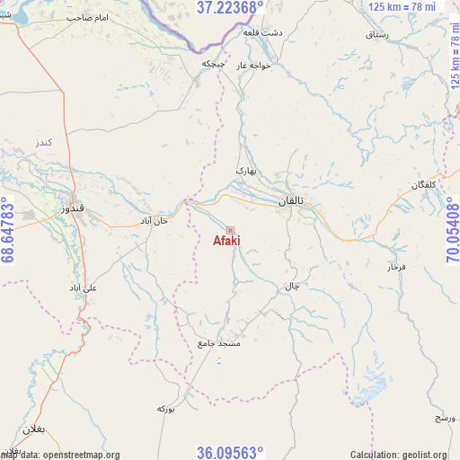
Afaki GPS coordinates[2]
36° 39' 42.192" North, 69° 21' 3.42" East
| Map corner | latitude | longitude |
|---|---|---|
| Upper-left | 37.22368°, | 68.64783° |
| Center: | 36.66172°, | 69.35095° |
| Lower-right: | 36.09563°, | 70.05408° |
| Map W x H: | 125.4×125.4 km | = 77.9×77.9mi |
| max Lat: | 38.4435° ⇑17.4% North |
| Afaki: | 36.66172° |
| min Lat: | ⇓82.6% South 30.15° |
| min Long | Afaki | max Long |
| 61.06667° | 69.35095° | 72.318° |
| W 69.5%⇐ | ⇒30.5% E |
Elevation
Elevation of Afaki is 711 m = 2333 ft, and this is 707.4 m = 2321 ft below average elevation for this country.
| Max E: |
3068 m = 10066 ft | 81% |
| Avg. | 1418.4 m = 4654 ft | |
| Afaki | 711 m = 2333 ft | |
Min E: |
254 m = 833 ft | 19% |
See also: Afghanistan elevation on elevation.city.
Geographical zone
Afaki is located in North temperate zone (between Tropic of Cancer and the Arctic Circle). Distance of this Northern Tropic circle is 1470.5 km =913.7 mi to South.| Distance of | km | miles | from Afaki |
|---|---|---|---|
| North Pole | 5930.7 | 3685.2 | to North |
| Arctic Circle | 3324.8 | 2065.9 | to North |
| Tropic Cancer | 1470.5 | 913.7 | to South |
| Equator | 4076.4 | 2533 | to South |


Nearby cities:
15 places around Afaki: (largest is in red/bold)
• Aliabad
43.2 km =26.8 mi,  248°
248°
• Būrkah
52 km =32.3 mi,  200°
200°
• Dasht-e Archī
54.9 km =34.1 mi,  342°
342°
• Dasht-e Qal‘ah
55.3 km =34.4 mi,  8°
8°
• Dowr-e Rabāţ
50 km =31.1 mi,  273°
273°
• Farkhār
46.3 km =28.8 mi,  102°
102°
• Kalafgān
54.3 km =33.7 mi,  76°
76°
• Khanabad
21.1 km =13.1 mi,  276°
276°
• Khwājah Ghār
45.4 km =28.2 mi, 7°
• Khānaqāh
17.1 km =10.6 mi, 103°
• Kunduz
44.7 km =27.8 mi, 279°
• Rustāq
67 km =41.6 mi,  39°
39°
• Taloqan
18.3 km =11.4 mi,  63°
63°
• Ārt Khwājah
48.5 km =30.1 mi, 13°
• Ţāqchah Khānah
25.2 km =15.7 mi, 100°
Sources, notices
• [Note1] Compared only with cities in Afghanistan existing in our database
• [Src1] Map data: © OpenStreetMap contributors (CC-BY-SA)
• [Src2] Other city data from geonames.org with taken over terms of usage.
• [Src3] Geographical zone / Annual Mean Temperature by Robert A. Rohde @ Wikipedia
