Khanabad geodata
Khanabad (Kunduz) is a populated place; located in Afghanistan in Asia/Kabul (GMT+4.5) time zone. With population of 71,531 people, there are 12 cities with bigger population in this country. Compared to other cities in Afghanistan, 83.9% of cities are located further ↓South; 61.7% of cities are located further ←West and 88.1% of cities have higher elevation than Khanabad. Note1


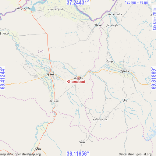
Khanabad GPS coordinates[2]
36° 40' 57" North, 69° 6' 56.016" East
| Map corner | latitude | longitude |
|---|---|---|
| Upper-left | 37.24431°, | 68.41244° |
| Center: | 36.6825°, | 69.11556° |
| Lower-right: | 36.11656°, | 69.81869° |
| Map W x H: | 125.4×125.4 km | = 77.9×77.9mi |
| max Lat: | 38.4435° ⇑16.1% North |
| Khanabad: | 36.6825° |
| min Lat: | ⇓83.9% South 30.15° |
| min Long | Khanabad | max Long |
| 61.06667° | 69.11556° | 72.318° |
| W 61.7%⇐ | ⇒38.3% E |
Elevation
Elevation of Khanabad is 503 m = 1650 ft, and this is 915.4 m = 3003 ft below average elevation for this country.
| Max E: |
3068 m = 10066 ft | 88.1% |
| Avg. | 1418.4 m = 4654 ft | |
| Khanabad | 503 m = 1650 ft | |
Min E: |
254 m = 833 ft | 11.9% |
See also: Khanabad elevation on elevation.city.
Geographical zone
Khanabad is located in North temperate zone (between Tropic of Cancer and the Arctic Circle). Distance of this Northern Tropic circle is 1472.8 km =915.2 mi to South.| Distance of | km | miles | from Khanabad |
|---|---|---|---|
| North Pole | 5928.4 | 3683.7 | to North |
| Arctic Circle | 3322.5 | 2064.5 | to North |
| Tropic Cancer | 1472.8 | 915.2 | to South |
| Equator | 4078.7 | 2534.4 | to South |


Nearby cities:
15 places around Khanabad: (largest is in red/bold)
• Afaki
21.1 km =13.1 mi,  96°
96°
• Aliabad
26.3 km =16.3 mi,  227°
227°
• Būrkah
51.3 km =31.9 mi,  176°
176°
• Dasht-e Archī
50.3 km =31.3 mi,  5°
5°
• Dasht-e Qal‘ah
60 km =37.3 mi,  29°
29°
• Dowr-e Rabāţ
29 km =18 mi,  271°
271°
• Farkhār
67.3 km =41.8 mi, 100°
• Imām Şāḩib
58.5 km =36.4 mi,  344°
344°
• Khwājah Ghār
50.6 km =31.4 mi, 32°
• Khānaqāh
38.1 km =23.7 mi, 99°
• Kunduz
23.6 km =14.7 mi,  282°
282°
• Qarāwul
66.7 km =41.4 mi,  333°
333°
• Taloqan
37.8 km =23.5 mi,  80°
80°
• Ārt Khwājah
55.3 km =34.4 mi,  35°
35°
• Ţāqchah Khānah
46.3 km =28.8 mi, 98°
Sources, notices
• [Note1] Compared only with cities in Afghanistan existing in our database
• [Src1] Map data: © OpenStreetMap contributors (CC-BY-SA)
• [Src2] Other city data from geonames.org with taken over terms of usage.
• [Src3] Geographical zone / Annual Mean Temperature by Robert A. Rohde @ Wikipedia
