Dasht-e Qal‘ah geodata
Dasht-e Qal‘ah (Takhar) is a seat of a second-order administrative division; located in Afghanistan in Asia/Kabul (GMT+4.5) time zone. In our database, there are 93 cities with bigger population. Compared to other cities in Afghanistan, 95.2% of cities are located further ↓South; 72.3% of cities are located further ←West and 90.7% of cities have higher elevation than Dasht-e Qal‘ah. Note1


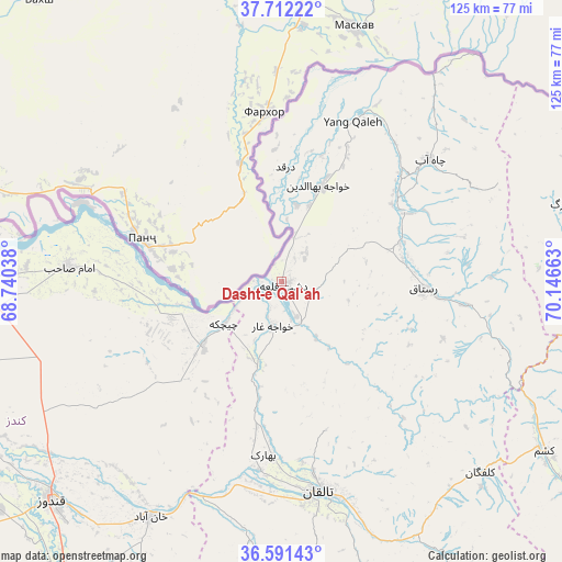
Dasht-e Qal‘ah GPS coordinates[2]
37° 9' 14.04" North, 69° 26' 36.6" East
| Map corner | latitude | longitude |
|---|---|---|
| Upper-left | 37.71222°, | 68.74038° |
| Center: | 37.1539°, | 69.4435° |
| Lower-right: | 36.59143°, | 70.14663° |
| Map W x H: | 124.6×124.6 km | = 77.4×77.4mi |
| max Lat: | 38.4435° ⇑4.8% North |
| Dasht-e Qal‘ah: | 37.1539° |
| min Lat: | ⇓95.2% South 30.15° |
| min Long | Dasht-e Qal‘a | max Long |
| 61.06667° | 69.4435° | 72.318° |
| W 72.3%⇐ | ⇒27.7% E |
Elevation
Elevation of Dasht-e Qal‘ah is 449 m = 1473 ft, and this is 969.4 m = 3180 ft below average elevation for this country.
| Max E: |
3068 m = 10066 ft | 90.7% |
| Avg. | 1418.4 m = 4654 ft | |
| Dasht-e Qal‘ah | 449 m = 1473 ft | |
Min E: |
254 m = 833 ft | 9.3% |
See also: Afghanistan elevation on elevation.city.
Geographical zone
Dasht-e Qal‘ah is located in North temperate zone (between Tropic of Cancer and the Arctic Circle). Distance of this Northern Tropic circle is 1525.2 km =947.7 mi to South.| Distance of | km | miles | from Dasht-e Qal‘ah |
|---|---|---|---|
| North Pole | 5875.9 | 3651.1 | to North |
| Arctic Circle | 3270 | 2031.9 | to North |
| Tropic Cancer | 1525.2 | 947.7 | to South |
| Equator | 4131.1 | 2566.9 | to South |


Nearby cities:
15 places around Dasht-e Qal‘ah: (largest is in red/bold)
• Afaki
55.3 km =34.4 mi,  188°
188°
• Chāh Āb
42.6 km =26.5 mi,  50°
50°
• Darqad
25.6 km =15.9 mi,  1°
1°
• Dasht-e Archī
24.6 km =15.3 mi,  264°
264°
• Imām Şāḩib
45.1 km =28 mi,  274°
274°
• Kalafgān
61.5 km =38.2 mi,  133°
133°
• Khanabad
60 km =37.3 mi,  209°
209°
• Khwājah Ghār
10 km =6.2 mi, 191°
• Khānaqāh
59.3 km =36.8 mi,  171°
171°
• Qarāwul
59.2 km =36.8 mi,  277°
277°
• Rustāq
34.4 km =21.4 mi,  95°
95°
• Taloqan
47.2 km =29.3 mi, 170°
• Yangī Qal‘ah
37.7 km =23.4 mi,  23°
23°
• Ārt Khwājah
8.2 km =5.1 mi,  157°
157°
• Ţāqchah Khānah
61.7 km =38.3 mi, 164°
Sources, notices
• [Note1] Compared only with cities in Afghanistan existing in our database
• [Src1] Map data: © OpenStreetMap contributors (CC-BY-SA)
• [Src2] Other city data from geonames.org with taken over terms of usage.
• [Src3] Geographical zone / Annual Mean Temperature by Robert A. Rohde @ Wikipedia
