Lubango geodata
Lubango (Huíla) is a seat of a first-order administrative division; located in Angola in Africa/Luanda (GMT+1) time zone. With population of 102,541 people, there are 6 cities with bigger population in this country. Compared to other cities in Angola, 94.4% of cities are located further ↑North; 83.3% of cities are located further →East and 97.2% of cities have lower elevation than Lubango. Note1


Lubango GPS coordinates[2]
14° 55' 1.812" South, 13° 29' 33" East
| Map corner | latitude | longitude |
|---|---|---|
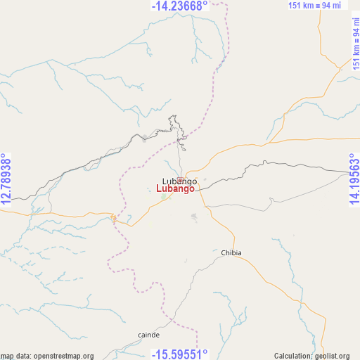
| Upper-left | -14.23668°, | 12.78938° |
| Center: | -14.91717°, | 13.4925° |
| Lower-right: | -15.59551°, | 14.19563° |
| Map W x H: | 151.1×151.1 km | = 93.9×93.9mi |
| max Lat: | -5.55° ⇑94.4% North |
| Lubango: | -14.91717° |
| min Lat: | ⇓5.6% South -17.06667° |
| min Long | Lubango | max Long |
| 12.15222° | 13.4925° | 22.22466° |
| W 16.7%⇐ | ⇒83.3% E |
Elevation
Elevation of Lubango is 1760 m = 5774 ft, and this is 791.1 m = 2595 ft above average elevation for this country.
| Max E: |
1895 m = 6217 ft | 2.8% |
| Lubango | 1760 m 5774 ft | |
| Avg. | 968.9 m = 3179 ft | |
Min E: |
1 m = 3 ft | 97.2% |
See also: Lubango elevation on elevation.city.
Geographical zone
Lubango is located in South Torrid zone (between Equator and Tropic of Capricorn). Distance of this Southern Tropic circle is 947.3 km =588.6 mi to South.| Distance of | km | miles | from Lubango |
|---|---|---|---|
| Equator | 1658.6 | 1030.6 | to North |
| Tropic Capricorn | 947.3 | 588.6 | to South |
| Antarctic Circle | 5742.5 | 3568.2 | to South |
| South Pole | 8348.4 | 5187.5 | to South |


Nearby cities:
13 places around Lubango: (largest is in red/bold)
• Benguela
260.5 km =161.9 mi,  357°
357°
• Caconda
214.7 km =133.4 mi,  52°
52°
• Catumbela
276.6 km =171.9 mi,  1°
1°
• Caála
320.2 km =199 mi,  44°
44°
• Chela
358.5 km =222.8 mi, 35°
• Chinjenje
273.7 km =170.1 mi, 36°
• Huambo
339.8 km =211.1 mi, 45°
• Lobito
283.9 km =176.4 mi, 0°
• Longonjo
293.4 km =182.3 mi, 40°
• Namibe
147.2 km =91.5 mi,  257°
257°
• Ondjiva
338.3 km =210.2 mi,  134°
134°
• Sumbe
414.4 km =257.5 mi,  5°
5°
• Uacu Cungo
433.2 km =269.2 mi,  23°
23°
Sources, notices
• [Note1] Compared only with cities in Angola existing in our database
• [Src1] Map data: © OpenStreetMap contributors (CC-BY-SA)
• [Src2] Other city data from geonames.org with taken over terms of usage.
• [Src3] Geographical zone / Annual Mean Temperature by Robert A. Rohde @ Wikipedia
