Chinjenje geodata
Chinjenje (Huambo) is a seat of a second-order administrative division; located in Angola in Africa/Luanda (GMT+1) time zone. In our database, there are 36 cities with bigger population. Compared to other cities in Angola, 86.1% of cities are located further ↑North; 61.1% of cities are located further →East and 100% of cities have lower elevation than Chinjenje. Note1


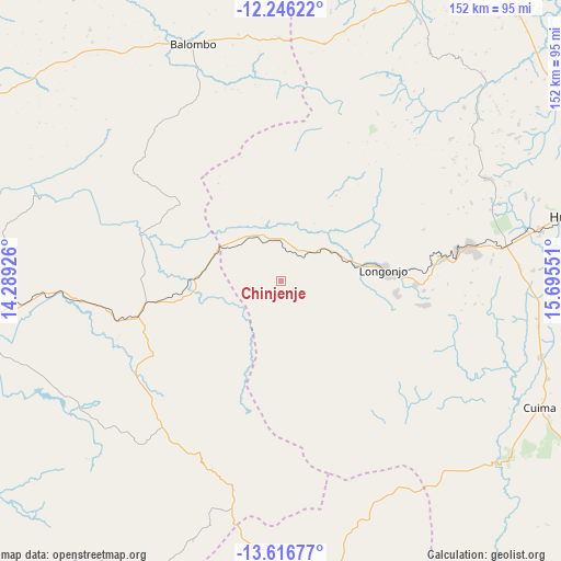
Chinjenje GPS coordinates[2]
12° 55' 56.784" South, 14° 59' 32.568" East
| Map corner | latitude | longitude |
|---|---|---|
| Upper-left | -12.24622°, | 14.28926° |
| Center: | -12.93244°, | 14.99238° |
| Lower-right: | -13.61677°, | 15.69551° |
| Map W x H: | 152.4×152.4 km | = 94.7×94.7mi |
| max Lat: | -5.55° ⇑86.1% North |
| Chinjenje: | -12.93244° |
| min Lat: | ⇓13.9% South -17.06667° |
| min Long | Chinjenje | max Long |
| 12.15222° | 14.99238° | 22.22466° |
| W 38.9%⇐ | ⇒61.1% E |
Elevation
Elevation of Chinjenje is 1895 m = 6217 ft, and this is 926.1 m = 3038 ft above average elevation for this country.
| Max E: |
1895 m = 6217 ft | 0% |
| Chinjenje | 1895 m 6217 ft | |
| Avg. | 968.9 m = 3179 ft | |
Min E: |
1 m = 3 ft | 100% |
See also: Angola elevation on elevation.city.
Geographical zone
Chinjenje is located in South Torrid zone (between Equator and Tropic of Capricorn). Distance of this Southern Tropic circle is 1168 km =725.8 mi to South.| Distance of | km | miles | from Chinjenje |
|---|---|---|---|
| Equator | 1438 | 893.5 | to North |
| Tropic Capricorn | 1168 | 725.8 | to South |
| Antarctic Circle | 5963.2 | 3705.4 | to South |
| South Pole | 8569.1 | 5324.6 | to South |


Nearby cities:
15 places around Chinjenje: (largest is in red/bold)
• Benguela
176.6 km =109.7 mi,  282°
282°
• Caconda
89.4 km =55.6 mi,  174°
174°
• Catabola
263.4 km =163.7 mi,  70°
70°
• Catumbela
166.5 km =103.5 mi,  289°
289°
• Caála
62.2 km =38.6 mi,  81°
81°
• Chela
84.8 km =52.7 mi,  34°
34°
• Chissamba
268 km =166.5 mi, 71°
• Cuito
219.2 km =136.2 mi, 73°
• Huambo
82.8 km =51.4 mi, 77°
• Lobito
170.2 km =105.8 mi, 291°
• Longonjo
28.4 km =17.6 mi, 84°
• Lubango
273.7 km =170.1 mi,  216°
216°
• Quibala
244.5 km =151.9 mi,  359°
359°
• Sumbe
229 km =142.3 mi,  326°
326°
• Uacu Cungo
175.7 km =109.2 mi,  4°
4°
Sources, notices
• [Note1] Compared only with cities in Angola existing in our database
• [Src1] Map data: © OpenStreetMap contributors (CC-BY-SA)
• [Src2] Other city data from geonames.org with taken over terms of usage.
• [Src3] Geographical zone / Annual Mean Temperature by Robert A. Rohde @ Wikipedia
