Benguela geodata
Benguela is a seat of a first-order administrative division; located in Angola in Africa/Luanda (GMT+1) time zone. With population of 151,226 people, there are 4 cities with bigger population in this country. Compared to other cities in Angola, 75% of cities are located further ↑North; 86.1% of cities are located further →East and 88.9% of cities have higher elevation than Benguela. Note1


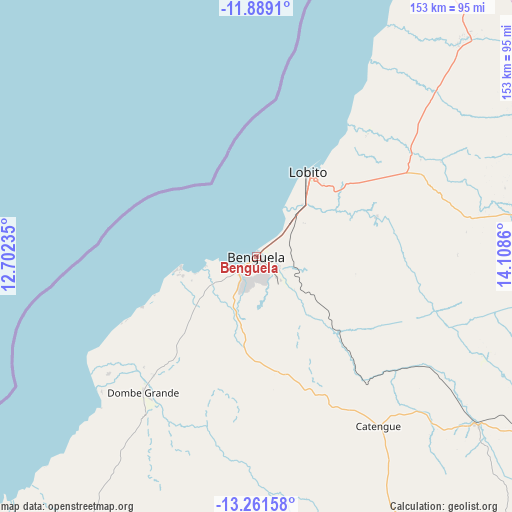
Benguela GPS coordinates[2]
12° 34' 34.536" South, 13° 24' 19.692" East
| Map corner | latitude | longitude |
|---|---|---|
| Upper-left | -11.8891°, | 12.70235° |
| Center: | -12.57626°, | 13.40547° |
| Lower-right: | -13.26158°, | 14.1086° |
| Map W x H: | 152.6×152.6 km | = 94.8×94.8mi |
| max Lat: | -5.55° ⇑75% North |
| Benguela: | -12.57626° |
| min Lat: | ⇓25% South -17.06667° |
| min Long | Benguela | max Long |
| 12.15222° | 13.40547° | 22.22466° |
| W 13.9%⇐ | ⇒86.1% E |
Elevation
Elevation of Benguela is 11 m = 36 ft, and this is 957.9 m = 3143 ft below average elevation for this country.
| Max E: |
1895 m = 6217 ft | 88.9% |
| Avg. | 968.9 m = 3179 ft | |
| Benguela | 11 m = 36 ft | |
Min E: |
1 m = 3 ft | 11.1% |
See also: Benguela elevation on elevation.city.
Geographical zone
Benguela is located in South Torrid zone (between Equator and Tropic of Capricorn). Distance of this Southern Tropic circle is 1207.6 km =750.4 mi to South.| Distance of | km | miles | from Benguela |
|---|---|---|---|
| Equator | 1398.3 | 868.9 | to North |
| Tropic Capricorn | 1207.6 | 750.4 | to South |
| Antarctic Circle | 6002.8 | 3730 | to South |
| South Pole | 8608.7 | 5349.2 | to South |


Nearby cities:
15 places around Benguela: (largest is in red/bold)
• Caconda
221.1 km =137.4 mi,  125°
125°
• Catumbela
22.4 km =13.9 mi,  43°
43°
• Caála
235.8 km =146.5 mi,  97°
97°
• Chela
222.3 km =138.1 mi,  82°
82°
• Chinjenje
176.6 km =109.7 mi, 102°
• Cuito
383.6 km =238.4 mi,  86°
86°
• Huambo
254.1 km =157.9 mi, 95°
• Lobito
27.5 km =17.1 mi,  31°
31°
• Longonjo
203.7 km =126.6 mi, 100°
• Lubango
260.5 km =161.9 mi,  177°
177°
• Namibe
321.2 km =199.6 mi,  204°
204°
• N’dalatando
399.9 km =248.5 mi,  24°
24°
• Quibala
267.2 km =166 mi, 39°
• Sumbe
159.6 km =99.2 mi, 17°
• Uacu Cungo
230.3 km =143.1 mi,  53°
53°
Sources, notices
• [Note1] Compared only with cities in Angola existing in our database
• [Src1] Map data: © OpenStreetMap contributors (CC-BY-SA)
• [Src2] Other city data from geonames.org with taken over terms of usage.
• [Src3] Geographical zone / Annual Mean Temperature by Robert A. Rohde @ Wikipedia
