Caconda geodata
Caconda (Huíla) is a populated place; located in Angola in Africa/Luanda (GMT+1) time zone. With population of 10,549 people, there are 28 cities with bigger population in this country. Compared to other cities in Angola, 88.9% of cities are located further ↑North; 55.6% of cities are located further →East and 83.3% of cities have lower elevation than Caconda. Note1


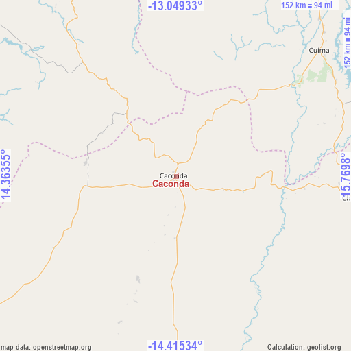
Caconda GPS coordinates[2]
13° 43' 59.988" South, 15° 4' 0.012" East
| Map corner | latitude | longitude |
|---|---|---|
| Upper-left | -13.04933°, | 14.36355° |
| Center: | -13.73333°, | 15.06667° |
| Lower-right: | -14.41534°, | 15.7698° |
| Map W x H: | 151.9×151.9 km | = 94.4×94.4mi |
| max Lat: | -5.55° ⇑88.9% North |
| Caconda: | -13.73333° |
| min Lat: | ⇓11.1% South -17.06667° |
| min Long | Caconda | max Long |
| 12.15222° | 15.06667° | 22.22466° |
| W 44.4%⇐ | ⇒55.6% E |
Elevation
Elevation of Caconda is 1674 m = 5492 ft, and this is 705.1 m = 2313 ft above average elevation for this country.
| Max E: |
1895 m = 6217 ft | 16.7% |
| Caconda | 1674 m 5492 ft | |
| Avg. | 968.9 m = 3179 ft | |
Min E: |
1 m = 3 ft | 83.3% |
See also: Angola elevation on elevation.city.
Geographical zone
Caconda is located in South Torrid zone (between Equator and Tropic of Capricorn). Distance of this Southern Tropic circle is 1078.9 km =670.4 mi to South.| Distance of | km | miles | from Caconda |
|---|---|---|---|
| Equator | 1527 | 948.8 | to North |
| Tropic Capricorn | 1078.9 | 670.4 | to South |
| Antarctic Circle | 5874.2 | 3650.1 | to South |
| South Pole | 8480.1 | 5269.3 | to South |


Nearby cities:
15 places around Caconda: (largest is in red/bold)
• Benguela
221.1 km =137.4 mi,  305°
305°
• Catabola
297.8 km =185 mi,  53°
53°
• Catumbela
219.3 km =136.3 mi, 311°
• Caála
111.6 km =69.3 mi,  28°
28°
• Chela
164 km =101.9 mi,  14°
14°
• Chinjenje
89.4 km =55.6 mi,  354°
354°
• Chissamba
301.1 km =187.1 mi, 54°
• Cuito
251.8 km =156.5 mi, 53°
• Huambo
128.9 km =80.1 mi, 34°
• Lobito
225.1 km =139.9 mi, 312°
• Longonjo
94.1 km =58.5 mi, 12°
• Lubango
214.7 km =133.4 mi,  232°
232°
• Menongue
301 km =187 mi,  109°
109°
• Sumbe
310.8 km =193.1 mi,  334°
334°
• Uacu Cungo
264.3 km =164.2 mi,  1°
1°
Sources, notices
• [Note1] Compared only with cities in Angola existing in our database
• [Src1] Map data: © OpenStreetMap contributors (CC-BY-SA)
• [Src2] Other city data from geonames.org with taken over terms of usage.
• [Src3] Geographical zone / Annual Mean Temperature by Robert A. Rohde @ Wikipedia
