Lobito geodata
Lobito (Benguela) is a populated place; located in Angola in Africa/Luanda (GMT+1) time zone. With population of 207,932 people, there are 3 cities with bigger population in this country. Compared to other cities in Angola, 66.7% of cities are located further ↑North; 80.6% of cities are located further →East and 97.2% of cities have higher elevation than Lobito. Note1


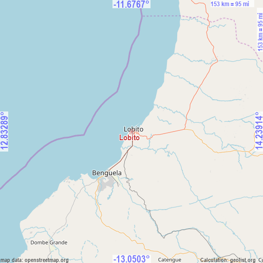
Lobito GPS coordinates[2]
12° 21' 51.84" South, 13° 32' 9.636" East
| Map corner | latitude | longitude |
|---|---|---|
| Upper-left | -11.6767°, | 12.83289° |
| Center: | -12.3644°, | 13.53601° |
| Lower-right: | -13.0503°, | 14.23914° |
| Map W x H: | 152.7×152.7 km | = 94.9×94.9mi |
| max Lat: | -5.55° ⇑66.7% North |
| Lobito: | -12.3644° |
| min Lat: | ⇓33.3% South -17.06667° |
| min Long | Lobito | max Long |
| 12.15222° | 13.53601° | 22.22466° |
| W 19.4%⇐ | ⇒80.6% E |
Elevation
Elevation of Lobito is 4 m = 13 ft, and this is 964.9 m = 3166 ft below average elevation for this country.
| Max E: |
1895 m = 6217 ft | 97.2% |
| Avg. | 968.9 m = 3179 ft | |
| Lobito | 4 m = 13 ft | |
Min E: |
1 m = 3 ft | 2.8% |
See also: Lobito elevation on elevation.city.
Geographical zone
Lobito is located in South Torrid zone (between Equator and Tropic of Capricorn). Distance of this Southern Tropic circle is 1231.1 km =765 mi to South.| Distance of | km | miles | from Lobito |
|---|---|---|---|
| Equator | 1374.8 | 854.3 | to North |
| Tropic Capricorn | 1231.1 | 765 | to South |
| Antarctic Circle | 6026.4 | 3744.6 | to South |
| South Pole | 8632.3 | 5363.9 | to South |


Nearby cities:
15 places around Lobito: (largest is in red/bold)
• Benguela
27.5 km =17.1 mi,  211°
211°
• Caconda
225.1 km =139.9 mi,  132°
132°
• Catumbela
7.4 km =4.6 mi,  170°
170°
• Caála
226.3 km =140.6 mi,  103°
103°
• Chela
206.2 km =128.1 mi,  88°
88°
• Chinjenje
170.2 km =105.8 mi,  111°
111°
• Cuito
369 km =229.3 mi, 90°
• Huambo
243.4 km =151.2 mi, 100°
• Longonjo
195.8 km =121.7 mi, 107°
• Lubango
283.9 km =176.4 mi,  180°
180°
• Namibe
348.5 km =216.5 mi, 205°
• N’dalatando
372.6 km =231.5 mi,  23°
23°
• Quibala
240 km =149.1 mi,  40°
40°
• Sumbe
133.1 km =82.7 mi,  14°
14°
• Uacu Cungo
205.3 km =127.6 mi,  56°
56°
Sources, notices
• [Note1] Compared only with cities in Angola existing in our database
• [Src1] Map data: © OpenStreetMap contributors (CC-BY-SA)
• [Src2] Other city data from geonames.org with taken over terms of usage.
• [Src3] Geographical zone / Annual Mean Temperature by Robert A. Rohde @ Wikipedia
